Friday, September 24, 2010

Manali - Valley of the Gods

Once called the "end of the habitable world," Manali is an important hill station of northern India and is the destination of thousands of tourists every year. Its cool atmosphere provides a perfect haven for the ones afflicted by the hot Indian summers. Besides offering quite a few places for sightseeing, Manali is also famous for adventure sports like skiing, hiking, mountaineering, paragliding, rafting, trekking, kayaking, and mountain biking. In brief, Manali-the veritable "valley of the Gods"-is an ideal place for the ones in search of both adventure and comfort. The Kullu is in brightly patterned puttoos, Tibetan women wearing ankle-length rainbow-striped pinafores, Nepali porters, Buddhist monks, and even the odd party of Zanskaris, swathed in fusty woolen gonchas, muddled together with souvenir-hunting Indian and Western tourists-all add up to the welcoming hubbub of Manali.

LOCATION
Situated in the central parts of the northern state of Himachal Pradesh, Manali is at the head of the Kullu valley, 280 km north of the state capital Shimla and 108 km from Mandi. Manali is perched at an altitude of 2050 meters above sea level and is spread along the banks of the river Beas. In winters, the temperature can drop below freezing point when heavy woolens are required. Summer temperatures are mild and light woolens/cottons are recommended. In Manali, one can find high mountains shrouded by silent snows and deep boulder strewn gorges. There are thick forests, filled with cool breezes and bird song. There are fields of wild flowers, small picturesque hamlets and fruit-laden orchards, especially apples.

HISTORY
Manali has a pre-historic legend behind its name. Vaivasvata, the seventh incarnation of Manu, the first creation according to Hindu mythology, found a tiny fish in his bathing water. The fish told him to look after it with devotion, for one day it would do him a great service. The seventh Manu cared for the fish until it grew so huge that he released it into the sea. Before departing, the fish warned Manu of an impending deluge when the entire world would be submerged and bade him to build a seaworthy ark. When the flood came, Matsya (fish), the first avatar of Lord Vishnu, towed Vaivasvata and the Seven Sages to safety. As the waters subsided, the seventh Manu's ark came to rest on a hillside and the place was named Manali after him.

TOURISTS ATTRACTIONS

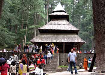
The often visited site in Manali is the Hidimba or Dhungri Temple. Erected in 1533, this temple is dedicated to the local deity Hidimba, wife of the Pandava prince, Bhim. A major festival is held here in the month of May. The temple is noted for its four-storeyed pagoda and exquisite wooden carvings.

Manali is known for its shiny gompas or Buddhist monasteries. With the highest concentration of Tibetan refugees in the entire Kullu valley, it is famous for its Gadhan Thekchhokling Gompa, built in 1969. The monastery is maintained by donations from the local community and through the sale of hand-woven carpets in the temple workshop.

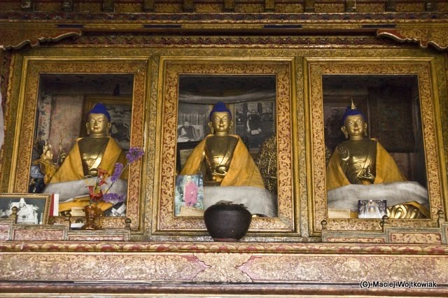
The smaller and more modern Himalayan Nyingamapa Gompa stands nearer the bazaar, in a garden blooming with sunflowers. Its main shrine, lit by dozens of electric bulbs and fragrant with Tibetan incense, houses a colossal gold-faced Buddha, best viewed from the small room on the first floor.

The Museum of Traditional Himachal Culture, near the Hidimba temple, is worth a visit, which houses artifacts of folk art of the entire Kullu valley.

PLACES AROUND MANALI

At a distance of 3 km northwest of Manali is Old Manali, famous for its orchards and old guesthouses. There is ruined fort here by the name of Manaligarh. There is also the Manu Maharishi Temple, dedicated to sage Manu.

Vaishisht, around 3 km from Manali, also boasts a pair of old stone temples, opposite each other above the main square. Dedicated to the local patron saint Vashista, the smaller of the two opens on to a partially covered courtyard, and is adorned with elaborate woodcarvings. Those lining the interior of the shrine, blackened by years of oil-lamp and incense smoke, are particularly fine. The temple tanks are underground hot-water/sulfur springs.

Rohtang Pass, at an altitude of 13,050 feet above sea level, is another adventure tourist site where it can be chilly even on summer day. Close by is a small lake called Dassaur Lake. Beas Kund, the source of river Beas, is also nearby.

Solang Nullah, 13 km northwest of Manali, is famous for its 300-meter ski lift. It is a picturesque spot and offers splendid views of glaciers and the snow-capped mountains. Jagatsukh, the former capital of Manali, is also an important spot.

ADVENTURE SPORTS

Skiing is a major pastime in Manali. Facilities for skiing are available at Solang Nullah (January-March) and Rohtang La (during summer). The Mountaineering Institute at Solang Nullah is a good training institute. Heli skiing is possible at the deep snowfields.

The Mountaineering Institute and Allied Sports is about 3 km from the Mall and offers mountaineering and kayaking courses. Kayaking is possible on the Beas River.

There are several good hikes from Manali. The 12-km hike up the western banks of the Beas to the Solang Valley is noteworthy. Lama Dugh meadow is a 6-km hike up to the Manalsu Nala, west of Manali town.

In the summers, several travel agencies organize paragliding on the slopes of the Solang Nullah. The charges generally include accommodation, food, equipment, and a guide, but not transport.

From May to July and, depending on the monsoons, from mid-September to mid-October, some basic rafting is possible on the Beas. The trips generally begin at Pirdi and continue 16 km down to Jhiri.

The HPTDC provides day permits for fishing. Permits can be obtained also at Patlikhul. Angling in the Kullu valley is possible at Larji, Katrain and Kasol.

HOW TO REACH
BY AIR - The nearest airport is Bhuntar, 52 km south of Manali. There are flights to Delhi via Shimla.

BY RAIL - The closest narrow-gauge railhead is at Jogindernagar, 135 km away. The closest broad-gauge railheads are Chandigarh (310 km) and Ambala (355 km).

BY ROAD - The distance from Delhi via Mandi is 585 km, and from Shimla the distance is 270 km.

Thursday, September 23, 2010

Shimla - Capital of Himachal Pradesh

Shimla (also known as Simla) is a tourist destination par excellence. It is a beautiful hill town in the lap of nature, surrounded by pine and deodar forests, It is one of India's most famous hill stations, derives its name from Goddess Shyamala, an incarnation of Goddess Kali, the deity of power and wrath.

However, unlike its name, Shimla is a perfect heaven for the ones in search of tranquility. Nature has blessed this capital city with innumerable gifts and man has used them to make Shimla one of India's best locales.

LOCATION
Perched at an altitude of 2159 m above sea level, Shimla is located towards the southern parts of the north Indian state of Himachal Pradesh. It is the state capital and is at a distance of 343 km from Delhi, 260 km from Manali, and 119 km from Chandigarh. The temperature range is not very high and the maximum temperature rarely crosses 25°C during summers. Winters are cold due to the chilly winds from the upper Himalayas. Around Christmas, Shimla experiences snowfall. The best season to visit Shimla is between September and November.

HISTORY
The British discovered Shimla in the form of a little village in 1819. Until then, it was a part of the Nepalese kingdom. It was during Lord William Bentinck's time that Shimla was truly acquired by the Government of India. The British persuaded the local Raja to part with the land in 1830, and the settlement became the subcontinent's most fashionable summer resort. In 1864, Shimla was declared the summer capital of India. After the independence of India, Shimla became the capital of Punjab until 1966, when it came under Himachal Pradesh.

TOURISTS ATTRACTIONS

• The hub of Shimla is the Mall, which runs along the Ridge and is crowded with tourists. It is the city's most famous shopping center, with shops selling all items, from clothes to junk food. The Ridge is a large open space in the heart of the town and presents excellent views of the mountain ranges. Most of Shimla's landmarks are located here. The Mall further joins the Ridge at the 'Scandal Point' of Kipling's Shimla, where a statue of the nationalist leader Lala Lajpat Rai has been erected.

• The six-storeyed Vice-Regal Lodge or Rashtrapati Niwas, about 4.5 km from Scandal Point, attracts many visitors. It was built in 1888 and was formerly the residence of Lord Dufferin, the British Viceroy. The style of architecture is English Renaissance, the masonry of the walling is light blue limestone and the wrought stonework is done in sandstone in a beautiful light gray tint. It has magnificent lawns and houses the Indian Institute of Advanced Study. Nearby is the Himalayan aviary that has a good collection of birds, including the Monal pheasant, Himachal's state bird.

• About 2.5 km from Scandal Point is the State Museum, which has a good collection of statues, miniatures, coins and photos from in and around Himachal Pradesh. It was built in 1974.

• Another of Shimla's major landmarks is the Christ Church and St. Michael's Cathedral. It is the second oldest church in Northern India built between 1846 and 1857. It is located just off the Mall, below the District Center and is known for its stained glass windows.

Jhaku temple, dedicated to Hanumanji, the attendant of Lord Rama, is to the east of the town center, near the highest point of the Shimla Ridge. It is at a height of 8048 feet above sea level and offers a panoramic view of the city.

• The temple just below the Grand Hotel is the temple dedicated to Shyamala Devi, an incarnation of Goddess Kali.

• Southeast from Jhaku is the long spur of Chotta Shimla, with Barnes Court. Once the residence of the Governor General of Punjab, it is now the official residence of the Governor of Himachal Pradesh.

• About 4 km from the Ridge, a sprightly stream flows through the Glen forests at an altitude of 1830 meters. It is a secluded picnic spot.

• Beyond the Glen is Annandale, another picnic spot. It is covered with deodar forests and was once the playgrounds of Shimla, where racing, polo and cricket entertained the Britishers.

• Elysium Hill, on the road leading through Lakkar Bazaar, houses the famous Auckland House, the former residence of Viceroy Lord Auckland. It is a well-known girls' school now. Nearby is the Stirling Castle, now an orphanage for the Tibetan children and a center for the Tibetan exiles who have settled locally.

PLACES AROUND SHIMLA

• Rampur has the Padam Palace built in 1925. The whole area is a maze of lanes, shops and temples. In the month of November, the Lavi Fair is organized here.

• On the Mahasu range, at Charabra, 13 km from Shimla, is the Wild Flower Hall situated at an altitude of 2,498 m. Nestling among picturesque sylvan surroundings, the Wild Flower Hall commands a breathtaking view of the snows. A major fire damaged it in 1993. Serving as a hotel today, it attracts many tourists who wish to revisit the grandeur of a bygone era.

• About six miles from the Shimla Church, in Koti, lay the village of Mashobra, at a height of 2149 m. A place of unique beauty, Mashobra is an ideal interlude beneath the oaks and the pines. Featuring beautiful gardens spattered with the daffodils, hyacinths, asphodels and celandines, it is a popular weekend resort, dotted with delightful villas and innumerable picnic spots. From here, a track leads down to Sipur, which is an exquisite glade shaded by ancient deodar trees. A fair is held here every April/May. About 3 km from Mashobra is the lovely resort of Craignano.

• At a distance of 5 km from Shimla is Summer Hill, a quiet suburb with peaceful environs ideal for secluded walks. About 2 km from Summer Hill are the Chadwick Falls, a silent gorge frequently visited by picnickers.

• Four kilometers from Shimla is Bihargaon, a village known for its splendid Himachali architecture.

• At a distance of 6 km from Shimla is the Prospect Hill. At 2125 m and crowned by a temple dedicated to Kamna Devi, the hill offers breathtaking views of the area. Another temple dedicated to Tara Devi is located at a distance of 3 km from Shimla.

• About 12 km from Shimla, on the Kalka Road is Kasauli

• Kufri, at distance of 16 km from Shimla and at an altitude of 2510 m above sea level, is a site offering some famous hikes and wonderful snow for skiing. An enjoyable walk leads up to the Mahasu Peak. The Himalayan Nature Park here has a good collection of animals and birds found in the region.

• Narkanda, 64 km from Shimla, offers wonderful slopes for skiing. At an elevation of 2708 m, it has dense pine forests. Hatu peak, 8 km from Narkanda, provides a striking panorama of the plains below.

• Chail, 43 km from Shimla, is a lush green setting and was the former capital of the Patiala State. It has the world's highest cricket ground at a height of 2250 m, built in 1893. It is also a hiker's paradise and there is a wildlife sanctuary at a distance of 3 km from here.

• Sarahan is a small village worth visiting. It provides a spectacular view of Shrikhand Mahadev and hiking opportunities to the nearby villages such as Ranwin and Bashal Peak. The Bhimakali temple, dedicated to Goddess Durga, is the finest example of Himachali architecture.

• Naldehra, at an altitude of 2050 m and 23 km from Shimla, houses the oldest and the highest golf course in India. In the middle of the course is a temple, Mahunag Mandir. It was a favorite pastime spot of Lord Curzon.

• Tattapani, 51 km from Shimla, is a spot well known for hot sulfurous springs.

GETTING THERE
By Air - Nearest airport to Shimla is at Jubberhatti, 26 km from Shimla. It has connecting flights to Delhi and Kullu. The nearby Chandigarh airport is, however, more handy as it is connected to all the major airports in India.

By Road - Shimla is well connected by road with Kalka, Chandigarh, Ambala, Delhi, Dehradun, Ludhiana, Jalandhar, Amritsar, Jammu and other towns of Punjab and Haryana.

By Train - Shimla is connected by a broad gauge line up to Kalka. From Kalka to Shimla, a narrow gauge line covers 96 kilometers, of track. The journey by train, which takes about six hours, crossing 103 tunnels is one of the finest ways of enjoying the scenic beauty. There is another option for a fast train Shiwalik Express or a delightful ride in the Rail Car.

The Rail Car takes about 4 hours. Kalka has direct rail connections with Delhi, Calcutta and Amritsar.

SPORTS & ADVENTURE IN SHIMLA
Shimla has the only natural ice-skating rink in India. An Ice-skating Carnival is arranged every year by the Ice-skating Club during January. During this festival, members display their skill on ice and participate in a fancy dress competition.

The summer festival in Shimla offers the best entertainment of the year. Artists are invited from all parts of Himachal Pradesh and from other parts of the country to entertain visitors with song, dance and music both Indian and Western.

Besides the summer festival, regular cultural programmes are organized in Shimla during the tourist season.

Kufri is a popular ski resort and is at a distance of 16-kms from Shimla. With thick woods around, Kufri offers a panoramic view of 2,000 miles of the great Himalayan ranges. Naldhera is another adventure area that is situated at a distance of 23-kms from the hill station. Naldhera is blessed with a thick cedar forest, attractive picnic spot and a 16-hole golf course. Fagu is another spot from where one can check out very fine views and has a lot of snow in winters for the delight of snow lovers and skiers.

Chabba is located on the road to Tattapani and is 53-kms away from Shimla. There is the one of the oldest hydroelectric power project, which is nowadays famous for river rafting. Situated 64-kms north of Shimla is Narkanda, at an altitude of 2,700m, a ski resort and also a popular spot for viewing the Himalayas particularly from the 3,300m high Hatu Peak.

Shimla to Kullu over the Jalori Pass (3300m) and Bashleo Pass (3250m) and Sarahan to Sangla are some popular treks.

Skiing slopes are at Narkanda (65 km. from Shimla) and Kufri (16 km from Shimla) (from Jan - mid March)

Naldehra offers a well groomed nine hole golf course.

At Rohru (100 km. from Shimla) & at Seema (9 km. from Rohru).

SHOPPING IN SHIMLA
There is an enormous range of goods that Shimla has to offer. This includes handicrafts, wood and metalwork, shawls, pullovers, local tweeds, caps, Tibetan carpets and pickles, jams and squashes.

Shimla is the best market for the handicrafts of Himachal Pradesh. Woollen and pashmina shawls, decorative items, handmade shoes, dolls, woollen caps, carved wooden sticks, toys and other items made form wood are made in Shimla itself and are on sale in the Lakkar Bazar. Tibetan jewellery and trinkets are found in the small Tibetan shops near the Ridge.

Jammu - City of Temples

Jammu is the second largest city of the northern Indian state of Jammu and Kashmir and is also its winter capital. Divided into two separate cities, the old town of Jammu is located on a hilltop overlooking the river Tawi while the new town is situated across the river, several kilometers away.

BEST TIME TO VISIT
Being near the Himalayas, the climate of the entire area is cold though summers are markedly warm. The temperatures range from 26.2°C to 4.3° C in winters and from 43.0°C to 23.4°C during summers. The recommended clothing for winters would be heavy/medium woolens while light cottons would be the best for summers in Jammu. Summers in Jammu are a sweltering, uncomfortable contrast to the cool climes of Kashmir. However, from October onwards, it becomes quite pleasant.

HISTORY
The city of Jammu is named after Jambu Lochan, the brother of Bahu, a powerful local chieftain who ruled during the ninth century. It is said that on becoming king, Jambu Lochan went on a hunt and, crossing the Tawi, found a deer and a tiger drinking water from the same tank. His ministers explained that this meant that the soil of the place was so virtuous that no living creature bore enmity against another. Raja Jambu Lochan, decided to build his capital, Jambupura, on this soil, on the right bank of the Tawi overlooking his brother king Bahu's fort. Jambupura later came to be known as Jammu.

Through the middle ages, Jammu prospered. Changes of rule at Delhi or Lahore passed over without disturbing the affluence of the town. The fertile cultivable land around the town constantly generated wealth and unlike many medieval towns, Jammu was never depopulated. The town was also a major stopover for caravans on the trade routes to Kashmir, Asia Minor and beyond and was a base for the fabled Silk Route.

The state of Jammu & Kashmir, which was earlier under the rule of Hindus and Muslims, came under the rule of Mughals under emperor Akbar. After the period of Afghan rule from 1756, it was annexed to the Sikh kingdom of the Punjab in 1819. In 1846, Ranjit Singh made over the territory of Jammu to Maharaja Gulab Singh and Jammu and Kashmir came into being as a single political and geographical entity following the Treaty of Amritsar between the British Government and Gulab Singh signed on March 16, 1846.

Since then, the state remained under the Dogra rule till the time India gained independence. At the time of independence, like all the state, Jammu and Kashmir was also given the option of either joining India or Pakistan. However, the then ruler, Maharaja Hari Singh decided not to exercise the option immediately but had to sign the instrument of accession when Pakistan attacked the territory later the same year.

TOURISTS ATTRACTIONS
Most of the tourists who come to the Jammu region have the Mata Vaishno Devi shrine as their destination, which is quite close by. However, the spirit of holiness permeates through the entire city, so much so that Jammu is also known as the 'City of Temples'. If Bahu Mata is the presiding deity of Jammu, the dargah of Peer Budhan Ali Shah is the other shrine that s believed to protect Jammuites. The other major tourist attraction is the Ragunath Temple Complex, which is the largest temple in North India devoted to Lord Ram. The construction of this temple was begun by Maharaja Gulab Singh in 1851 and completed by his son Ranbir Singh six years later.

The temple of Maha Kali (better known as Bahu or Bawey Wali Mata), located in the Bahu fort, is considered second only to Mata Vaishno Devi in terms of mystical power. The present temple was built shortly after the coronation of Maharaja Gulab Singh, in 1822. The existing fort, as well as the Manasabdar's palace inside it, were constructed in 1820 and are major tourist attractions of the city.

Other temples in the city include the Gauri Kund temple, Shudh Mahadev temple, Shiva temple, Peer Khoh Cave temple, Ranbireshwar temple and the Parmandal temple complex.

The most stunning site in Jammu is the Sheesh Mahal. The Pink Hall of the palace now houses the Dogra Art Museum, which has miniature paintings of the various hill schools. The museum also has the hand written Persian manuscripts of the Shahnama and Sikandernama. The palace was once the royal residence of the Dogra kings. Built as a group of buildings around a courtyard, the palace has a commanding view of river Tawi on one side and the city on the other.

The Amar Mahal Palace Museum is a beautiful palace of red sandstone, which stands amidst the most picturesque environs of Jammu. There is beautiful view of the Shivaliks in the north and river Tawi flows to the south adding to the grandeur. This was once the residential palace of Raja Amar Singh but now has been converted into a museum and is looked after by Hari-Tara Charitable trust. The museum has a golden throne made of 120 kg of pure gold.

A treat for those interested in history is the town of Akhnoor, 32 km southwest of Jammu. Standing on the banks of the mighty river Chenab, the town tells the tragic tale of the lovers Sohni and Mahiwal. Also along the riverbank are the majestic ruins of the Indus-Valley Civilization that are of great historical importance and command a beautiful view of the area around.

The Jujjar Kotli Tourist Complex, built on the banks of Jujjar rivulet, is at a distance of 35 km from Jammu. The crystal clear, cool water of Jujjar attracts picnickers in large numbers during the summer.

PLACES AROUND JAMMU
The Mansar Lake, situated 60 km away from Jammu is a beautiful lake fringed by forest-covered hills. Boating facilities are available here. Another attraction here is the Surinsar Mansar Wildlife, named after the two lakes on each corner of it. The sanctuary is spread over an area of 98 sq km and is home to species like the goral, wild boar, barking deer, leopard and a multitude of birds like, black partridge, red jungle fowl, peafowl, gray partridge, green pigeon, blue rock pigeon, Rufus turtle dove etc. Besides these, the forest area also houses some rare species of trees and orchids.

The small town Katra is 50 km away from Jammu and serves as the base camp for those visiting the holy shrine of Mata Vaishnodevi in the Trikuta Hills. The shrine can be reached on foot after traversing a 12 km long well laid footpath. Every year, nearly four million pilgrims pass through Katra on their way to the shrine. Accommodation in all the ranges is available for the pilgrims.

Kud is at a distance of 106 km from Jammu. This popular resort is situated on the Jammu-Srinagar highway, at an altitude of 1,738 meters. An ideal picnic spot, this place has a beautiful climate. Heavy woolens are required in winters while light/medium clothing is required in summers here. It is a very well developed hill station in the Udhampur district.

Patnitop is 112 km from Jammu. This famous hill resort is perched on a beautiful plateau, at an altitude of 2,024 meters across which the Jammu-Srinagar Highway passes. Enveloped by thickly wooded forests, Patnitop offers beautiful picnic spots, peaceful walks and breathtaking views of the mountains and the Chenab basin. In winter, the resort is generally covered with a thick blanket of snow thus providing opportunities for various adventure sports like skiing.

Sanasar is cup shaped meadow surrounded by gigantic conifers, situated at a distance of 119 km from Jammu. The right place for a quite holiday, the meadow has now been developed as a golf course. It also provides facilities for paragliding.

Batote, 125 km from Jammu, is situated at an altitude of 1,560 metres on the Jammu-Srinagar National Highway and is a popular health resort. Due to the panoramic view of the scenic areas around and the facilities provided for the tourists, this place is a favorite with travelers.

FAIRS & FESTIVALS
There is no city specific festival of Jammu as such. Normally, all the Hindu and other religious festivals are celebrated here with gaiety. However, what makes any celebration in Jammu different is the traditional dance and music of the Dogra Pahari region of Jammu. These songs and dances are performed on the occasion of feasts, festivals and marriages by the rural folk of this region. Men and women clad in their traditional costumes, participate in this musical revelry.

Besides, every year during Baisakhi in the month of April, a food and craft festival is organized near the Mansar Lake by the JKTDC.

HOW TO REACH
BY AIR - Jammu is well connected with the rest of the country by all the major means of transport. The city is accessible by air and the city has an airport. A number of flights are available to and from several of the major cities in the country.

BY RAIL - Jammu Tawi is the main railhead that has a number of trains for most of the important towns and cities of the country. Moreover, the longest rail route that stretches from Jammu Tawi to Kanyakumari and touches almost all the main cities and towns of the country, originates from here.

BY ROAD - One can easily reach Jammu by the National Highway 1A that goes from Punjab and runs through this city, connecting it to the rest of the state including the capital Srinagar.

Wednesday, September 22, 2010

Darjeeling - Queen of Hills

Darjeeling in India owes' its grandeur to its natural beauty, its clean fresh mountain air and above all, the smiling resilient people for whom it is a home. Known for its natural splendor, Darjeeling's best gift to its' visitors is the dawn of a new day. The mountains awaken first with a tentative peeking of the sun. A steep ride, five kilometers from Ghoom, or an invigorating walk up a steep incline, leads sun worshippers to Tiger Hill. The air is chilly with darkness and damp. To the east, a dull orange sun emerged painting the sky with brilliant strokes of magenta, gold, orange and fuchsia. The snow capped Everest, Kabru, Kanchenjunga, Jannu and other peaks slowly emerge from slumber to start a new day. The sun worshippers gasp at the magnificent sight. As the fog lifts in the slowly penetrating sun, the town gradually comes alive. Amidst brewing of tea, the sing-song Gorkhali which is the local dialect, rises and falls like music.

BEST TIME TO VISIT DARJEELING
The best time to visit Darjeeling in India is from March-May or September-November. The rains which start by May end are heavy downpours making living conditions cold and dreary. In winter there is a drastic fall in temperature from the summer's 15 to 25 degrees centigrade to 2 to 10 degrees in winter.

TOURISTS ATTRACTIONS OF DARJEELING
No visit to Darjeeling in India is complete without a visit to Ghoom which is 6 km away from the main town. The hillock is dominated by the famous Yiga Choeling Monastery which has 15 images of the Maitreya Buddha. Belonging to the yellow hat sect, the monastery contains many ancient palm leaf and paper manuscripts in Tibetan script. The Museum of Natural History is where one can see a fine collection of Himalayan animals, reptiles, birds and insects. If flora is what one enjoys, then Llyod Botanic Garden is the place of interest. It has a marvelous collection of alpine flora and orchids.

Padmaja Naidu Himalayan Zoological Park is the only center in India for the breeding of the rare snow leopard. The Ussurian tigers and the Himalayan black bear are also among its attractions. Neighboring the zoo is the Himalayan Mountaineering Institute established in 1954 by the then Prime Minister, Jawaharlal Nehru, in the wake of the conquest of Everest. Tenzing Norgay was its first Director and Advisor till his demise. A kilometer from the zoo is the Darjeeling-Rangit Valley ropeway. Considered the longest in Asia, it is a thrilling ride with splendid views. If one is looking for souvenirs, then the Tibetan Refugee Self Help Center. It produces excellent Tibetan crafts like carpets, wood and leather work. Established in 1959 after the Dalai Lama and his followers fled Tibet, it is a haven for ethnic Tibetan art.

PLACES AROUND DARJEELING
KALIMPONG - Across the river, Teesta lies lush Kalimpong. The road weaves lazily up a steep incline to suddenly open up to an unexpected panorama. The first sight to greet the eye is the steeple of the Mac Farlane Church. Once the headquarters of a Bhutanese Governor, the word kalim means king's minister and pong, the stronghold. It is also called Kalimpong or the black spur by the locals. However, the meaning that is popularly accepted is the Lepcha translation of the name which is "the ridge where we play" as the local tribesmen used to organize field sports here. At an altitude of 1250 meters, it has an area odd just 3.5 square miles with an approximate population of 40,000. Its rolling meadows are as yet untouched by tourism.

Prominent amongst the places of interest is a school, Dr. Graham's Homes which was founded by Dr. John Anderson Grahman in 1900. This has been built on the slopes of Delo Hill, three kilometers from the town. For a bird's eye view of the picturesque place, one has to go to Durpin Dara, an observatory point atop a hill from where one can get an awe-inspiring view of the mighty Himalayan ranges. Numerous monasteries dot the area among which the Pedong monastery and Thongsha Gompa are the oldest. Another monastery of interest is the Tharpa Choling Monastery constructed in 1937 by the Yellow Hat sect which is situated at Tirpai Hill at a distance of two kilometers from town.

About 4 km from town towards Teesta is located Kalimpong's famous Swiss Welfare Dairy. It was set up many years ago by a Swiss missionary, father Andrea Butty. Cheese, butter and other dairy products of this center are in great demand and the quality is comparable to the finest that is imported. The visit to Kalimpong won't be complete unless one spends several hours at the two bazaars. One on the main road, the other near 10th mile. It is a unique experience to see villagers turning up in their local costume at the bazaar on weekly market days to sell their farm products.

MIRIK - Set in idyllic surroundings, Mirik is the place for those seeking peace and tranquility. At an altitude of 1967 meters, the climate is cool and temperate. The Sumendu Lake at the bottom of Mirik Spur is the most dominating feature reflecting the magnificence of the eastern Himalayas. The lake is 1.2 kilometers long and is fed by perennial streams. Riding on the colorful boats or crossing the lake over an artistic bridge, leads one to a charming path through forests on the other side. Fishing is a popular past time here.

Mirik is also almost completely surrounded by some of the best tea gardens of the region. It is also the largest producer of oranges in West Bengal. The orchards are on a spur two kilometers from Mirik. Tourist cottage constructed from locally available material have been constructed in the dense forest and provide all modern facilities for a comfortable sojourn.

TREKKING TRACKS OF DARJEELING
Darjeeling in India was the first hill region where organized trekking was first conducted by Dr. Hooker in the 1840s. The breathtaking panoramic views of Everest and Kanchenjunga have been alluring thousands of nature lovers from different parts of the world since then. Treks in this region are organized through both high and low altitude areas.

The most popular of treks is the one through high altitude areas across the Singalila range in Darjeeling. The trek starts at Maneybhanjang (2134 m), goes to Meghma (2900 m), Toughu (3070 m), Gairibas (2621 m), Sandakphu (3636 m), and Phalut (3600m).The fourth and last day is the return trek to Darjeeling which may be taken along the along the same route or via Ramman, Rimbick and Bijanbari.

The best time of the year to undertake trek in Darjeeling in India is April-May and October-November. It is advisable to carry one's own provisions. Trekking equipment can be hired at nominal charges from the Youth Hostel, as well as some travel agencies.

HOW TO REACH DARJEELING
BY AIR - There are flights from Calcutta to Bagdogra which is 90 kilometers from south.

BY RAIL - The nearest railhead is Siliguri. The Toy train runs from New Jalpaiguri / Siliguri.

BY ROAD - We would provide you all India tourist permit vehicles for the local transportations and also for the intercity drives too.

SPECIAL FEATURE: JOURNEY BY TOY TRAIN IN DARJEELING
The narrow gauge railway lines fondly called the 'toy train' extend to over 4,500 kilometers mostly in the hilly regions of India. Among these one of the best known is the 83 kilometers long, 610 mm gauge 'toy' railway spanning the gorgeous terrain between Siliguri and Darjeeling. Nestled in the serene Himalayan splendor, the zigzag railway passing through a variety of foliage, linking Siliguri in north Bengal with Darjeeling, is a marvel of miniature rail engineering. The train girdles along streams and tea gardens on the way to Sukana, up a spur of the Singalele range from where the ascent of the line begins. The train strikes the first spiral or loop followed by the second in proximity of the 20 kilometer post, an amazing engineering feat, practically a double loop, for the rise from Rungtong to Tindharia. The third loop is about 22 kilometers away and lends an enchanting peep into the valley below with the Bhutan range in the east, the Teesta river and its Tiger island in the south-east. The sensational point of the fourth spiral, the Agony Point, is reached outside the Tindharia station.

The scenic beauty along the rail line is a thing of joy forever. From those stalwart sal trees, the railway track twists in and out of ravines, the tall cotton trees, the buttressed semul palms, the giant bamboo all entwined with creepers and loaded with ferns and moss. There are fig tress, oak and chestnut trees, the birch, the maple brambles and orchids, some of them interspersed with walnut trees and laurels until, in the vicinity of Cheem, the center of the Buddhist monastery of the Yellow Sect, there is that glorious glimpse of primroses, magnolias and rhododendrons. This luxurious vegetation is topped with sublime landscapes of snowy heights, more than a dozen peaks standing aloft above 6,000 meters - the renowned Kanchenjunga and the mountains of east Nepal, Sikkim and Tibet.

Tuesday, September 21, 2010

Leh - The capital of Ladakh

Leh, the capital of Ladakh is a fascinating destination. Age-old monasteries, quaint lanes, colorful markets and stunning views of the Himalayas make Leh an exotic destination. Leh is where your adventure in Ladakh begins. You can go trekking through the mountainous terrain of Ladakh, enjoy a game of polo in a high altitude arena or watch an archery contest where local residents compete in a contest that remains unchanged by time. Mountaineering, white water rafting and wildlife tours are other adventurous attractions of Leh Ladakh India. Though the weather can be freezing cold, the smiles on the faces of the Ladakhi people are sure to warm your heart. Feel on top of the world in Ladakh, on tours to Ladakh.

Leh is one of the favorite tourist destinations located in the northernmost parts of the country. Lapped in the snow-covered fringes of the Himalayas, Leh India has been the center of Tibet-Buddhist culture since ages. Its colorful gompas have attracted the devout Buddhists from all over the globe. Besides, it is also a favorite hiking locale and is known for some of the best hikes in India.

Location
The capital of the Ladakh district, Leh is towards the eastern parts of Jammu and Kashmir. It is perched at a height of 3,505 m above sea level. The region is watered by the Zanskar River, which flows into the Indus River just below. The Stok mountain range lies just south of Leh, while towards the north one can find the snow-capped Ladakh range. In the winters, it is freezing cold with temperatures going below 0°C.

History
Leh India became the regional capital in the 17th century, when King Sengge Namgyal shifted his court here from Shey (15 km southeast) to be closer to the head of the Khardung La-Karakoram corridor into China. Very soon, the town blossomed into one of the busiest markets on the Silk Route. Leh's prosperity, managed mainly by the Sunni Muslim traders, came to an abrupt end with the closure of the Chinese border in the 1950s. Only after the Indo-Pak wars of 1965 and 1971, when India rediscovered its strategic value, did Leh's fortunes begin to look up. Today, khaki-clad soldiers and their families from the nearby military and air force bases are the mainstay of the local economy in winter, when foreign visitors are few. It was in 1974 that Leh was opened up for tourists.

Tourists Attractions
A miniature version of the Potala in Lhasa, the Leh Palace is one of the major attractions here. The palace was built in the 17th century and is now dilapidated and deserted. It was the home of the royal family until they were exiled to Stok in the 1830s. Above the palace, at the top of the Namgyal hill, is the Victory Tower, built to commemorate Ladakh's victory over the Balti Kashmir armies in the early 16th century.

The Namgyal Tsemo Gompa, built in 1430, contains a three-story high Buddha image and ancient manuscripts and frescoes. The fort above this gompa is ruined, but the views of Leh from here are breathtakingly beautiful.

The Sankar gompa is located a couple of kilometers north of the town center. The gompa belongs to the Gelukpa order and has an impressive impression of the Buddhist deity Avalokiteshwara Padmahari or Chenresig, with 1,000 arms and an equal number of heads.

The Shanti Stupa was built by a Japanese order and was opened by the Dalai Lama in 1985. From the top, one can view the exotic locales nearby. The stupa is located at a distance of 3 km from the Fort Road.

The Mughal emperor Aurangzeb commissioned the mosque at the head of the Leh Bazaar. The Soma gompa lies near the mosque.

Places around Leh
Seventy kilometers from Leh India, on the banks of river Indus, is the Alchi gompa dating back to the 11th century. It is one of the largest and a famous monastery with a widely renowned collection of paintings.

At a distance of 45 km south of Leh, Hemis is one of the biggest gompas in Ladakh. Built in 1630, it belongs to the red sect, Brokpa. It is also known as Chang Chub Sam Ling or "the lone place of the compassionate person." To commemorate the birth of the renowned Indian sage, Padmasambhava, the annual Hemis festival is held in the month of June/July.

Situated on the opposite bank of the Indus across Thikse, the Matho gompa was established in the first half of the 16th century and has a valuable collection of old and beautiful thangkas, some in the form of 'mandalas.' Its annual festival of oracles in early March is an important event in the Ladakhi religious calendar.

Until the 16th century, the Shey gompa was the royal residence. It is located at a distance of 15 km south of Leh. This Palace Monastery has the largest statue of Maitreya Buddha (the Buddha to come) in Ladakh. Erected in the mid-17th century, worked out of gold and gilded copper sheets with blue hair, it stands 17.5 m high.

At a distance of 8 km from Leh, standing majestically on top of a hillock overlooking the Indus Valley, lies the Spituk Gompa. It was built in the 15th century and houses a collection of ancient masks, antique arms, icons and thangkas. Higher up the hill is the Mahakal Temple, containing the shrine of Vajrabhairava.

About 20 km south of Leh, Thikse gompa is an imposing monastery and one of the finest examples of Ladakhi architecture. It belongs to the Gelukpa order. The 12-story monastery complex contains numerous stupas, statues, thangkas, wall paintings, swords and a large pillar engraved with the Buddha's teachings.

Belonging to the Brokpa sect, the Phyang gompa was built in the 16th century. Located at a distance of 16 km from Leh, it houses hundreds of statues, thangkas, old manuscripts and some old weapons.

The Bagso gompa is located 40 km downstream from Leh, and was the seat of power of a branch of the Namgyal family. It is here in AD 1680 that invading Mongol and Tibetan armies were held in check over a three-year-long siege. Original 16th-century murals and other arts of Bagso are worth seeing.

About 45 km from Leh, the Chernry gompa is situated in a picturesque valley leading to Changia. It was constructed upon Sengge Namgyal's death in 1645. A large collection of scriptures with title pages in sterling silver and the text in gold letters is kept here.

Precariously perched atop a 200-meter-high crag, the Mulbekh gompa has an imposing rock carving of the future Buddha. On the other end of the valley is a phallus-shaped rock with a monastery at its base.

At a distance of 50 km east of Leh, the Thak Thog gompa is the only monastery belonging to the Nying-ma-pa order. Gum Rinpoche (Padma Sambhava) is said to have founded this monastery and the temple where he meditated is still to be seen here. Tu-Phuk houses the images of Guru-Tsan-gyet (eight forms of Padma Sambhava), Guru Takpo Tsahl and the 11-headed Avalokitesvara. The new monastery is built on ground level and contains the image of Guru Nang Srith Zilon in a central position. To its right is an image of Guru Dorje Dolo and on the left is an image of Guru Padma Gyalpo. There are seats for the Dalai Lama and Taklung Rinpoche (the incarnate Lama of the monastery). The monastery stages two festivals every year. Thak Thog Tse Chu is held from the ninth to the eleventh day of the sixth Tibetan month. Thak Thog Wangchogis is held from the 26th to the 29th day of the ninth Tibetan lunar month.

Near Leh, the town of Choglamsar is an important center for Tibetan Buddhism and the study of Tibetan study and culture. One can find here a Tibetan library, medical center, handicraft shops, study center, bookshops, plenty of restaurants and the Central Institute of Buddhist Studies.

How to reach Leh
There are regular flights from Delhi to Leh. There are two overland routes to Leh-the roads from Srinagar and Manali. The Leh-Srinagar road is usually open from June to October, while the Leh-Manali route is open from July to September.

Tuesday, September 7, 2010

Ahmedabad - Manchester of the East

Ahmedabad, the city of Ahmed Shah (Medieval ruler of Gujarat), is known for its rich past and its association with the Mahatma (Great Soul), also known as Mohandas Karamchand Gandhi. The city offers the traveler a unique style of architecture, which is a blend of Hindu and Islamic styles (Indo-Saracenic style of architecture). The monuments of Ahmedabad mainly date back to the 15th century. Ahmedabad has been known for its industry since medieval times. Presently it is famous for its textile mills and is often referred to as the 'Manchester of the East'.

LOCATION

Ahmedabad city is located in the state of Gujarat, in the western part of India. It lies along the Sabarmati River. Ahmedabad is 440 km north of Mumbai. The climate of Ahmedabad is hot and moist. Winters are cool and pleasant (November-February) but summers (April-June) are extremely dry, hot and the temperature can be as high as 46°C at times. The city experiences good rainfall during the monsoon season (July-September).

BEST TIME TO VISIT

As the city of Ahmedabad experiences a harsh summer season, and is lashed by the southwestern monsoons, the best time to visit Ahmedabad is during winters.

HISTORY

Ahmedabad has a chequered history. It has experienced a number of high points, followed by declines. It was founded by Sultan Ahmed Shah, the erstwhile ruler of Medieval Gujarat, in AD 1411. The city declined within a century of its being established. In 1572, Emperor Akbar seized it and assimilated it within the great Mughal Empire. Ahmedabad became an important business center during the Mughal period until the death of Aurangzeb in 1707, after which the city again began to decline. The British seized it in 1818 and set up a number of textile mills here. It became the temporary capital of the state of Gujarat from 1960 to 1970.

TOURIST ATTRACTIONS

Ahmedabad is a colorful city where one can enjoy the better things of life, be it food or amusement. The Walled City in Ahmedabad takes one down the memory lane, making one aware of the city’s glorious past. Ahmedabad has got numerous places of interest for tourists, ranging from monuments to amusement parks. The charm of the various museums, mosques, and forts complements the simplicity of the Ahmedabad city. While visiting the Ahmedabad city, one should keep the budget flexible, as it is all too common for people to get tempted by the array of artifacts, antiques, and the exotic and colorful attire available in Ahmedabad.

The Walled City (Pol): One of the must visit places in Ahmedabad is the walled city. One enters the walled city of Ahmedabad through a huge gate, which allows a glimpse into the affluence of the ancient buildings of the 18th century. The magnificence of the buildings, their richly carved woodwork and stone facades must be seen. The walled city of Ahmedabad houses people from a variety of religions-Muslims, Hindus and Jains. The walled city brings alive the glorious past of the Ahmedabad city leaving the tourists awe-struck.

Gandhi Ashram: Another tourist attraction of Ahmedabad is the Satyagraha Ashram (or the Gandhi Ashram). The Ashram is a place of see in Ahmedabad as it was the centre for the Indian freedom struggle and was set-up in AD 1920 on the lull western banks of the Sabarmati River. In AD 1930, Gandhi called upon the Indians to defy the Salt Tax imposed by the British. The whole of India rose to the call and from Gandhi Ashram rallied on the Dandi March to the sea with him.
Besides the ashram another place to visit in Ahmedabad is ‘Hridaya Kunj’-a simple cottage where Gandhi lived. The place is now preserved as a national monument. Amongst the places to be seen in Ahmedabad’s Gandhi Ashram are the Gandhi Memorial Centre, a library and a sound-and-light show displaying the Mahatma’s life and work.

Jama Masjid: Built by Ahmad Shah in AD 1423, near the Bhadra Fort, the Jama Masjid of Ahmedabad is one of the most striking mosques in India. The Jama Masjid is a place to visit in Ahmedabad owing to its Indo-Saracenic style of architecture and 15 domes resting upon 260 pillars.

Mosque of Sidi Sayid: Another place to be visited in Ahmedabad for its stone tracery and the motifs of the banyan tree on its windows is the Mosque of Sidi Sayid. The Mosque of Sidi Sayid is near the Lal Darwaza (Red Gateway) and is very close to the river end of the Relief Road in Ahmedabad. Ahmad Shah’s slave Sidi Sayid built the mosque in AD 1573.

Hathee Singh Jain Temple: Another place to be seen in Ahmedabad is the Hathee Singh Temple, outside the Delhi Gate, in pure white marble. The 52 shrines, each with an image of a Jain Tirthankar in the temple are places to be seen in Ahmedabad. This Jain temple of Ahmedabad was built by Sheth Hathee Singh in 1848 and is dedicated to Dharmanath, the fifteenth Jina or Jain apostle.

Sidi Bashir Mosque: Another tourist attraction of Ahmedabad city is the Sidi Bashir Mosque or the Shaking Minaret or Jhulta Minar outside the Sarangpur Gate. The place is to be seen to know that if one of the minarets is shaken, the other one begins to vibrate on its own without any provocation. The crucial mechanism that causes the vibration is still a mystery, and is enough to attract the curiosity of eager tourists in Ahmedabad. It is a belief that the vibration is a protection against any damage caused by earthquakes.

Kankaria Lake: Kankaria Lake is another tourist attraction of Ahmedabad. The Kankaria Lake is a circular lake constructed in AD 1451 by Sultan Qutub-ud-din. Amongst the places to be visited in the lake is the island garden at its centre with a summer palace known as Nagina Wadi. Lush green parks, an aquarium, a boat club, a natural historical museum, and a zoo surrounding the park make the lake a place to be seen in Ahmedabad. The ‘Bal Vatika’ or the children’s park makes it a great picnic spot and attracts tourists and localities from Ahmedabad alike.

Bhadra Fort and Teen Darwaza: The Bhadra Fort of Ahmedabad is another place to be visited in the city. The place is a venue for Republic Day and Independence Day celebrations in Ahmedabad. This fort of Ahmedabad fort has a temple devoted to the Mother Goddess, Bhadrakali; hence the name Bhadra Fort.

The huge and grand Teen Darwaza (Triple Gateway) is another place to be seen in Ahmedabad. Teen Darwaza servedthe purpose of a royal entrance to the Royal Square of the Bhadra Fort.

Calico Museum: One of the must visit places in Ahmedabad is the Calico museum of fabric, yarn and textiles. The place to be seen came into being in 1949 as a result of the painstaking efforts of Ms Gira Sarabhai. The museum is one place in Ahmedabad where designs, prints, and blocks from all over the world attract tourists from India as well as abroad. The Calico Museum of Textiles is located in Sarabhai House, a former haveli (bungalow) in the Shahi Bagh Gardens locality of Ahmedabad city.

The other places worth visiting in Ahmedabad are the Rani Rupmati’s Mosque, Rani Sipri’s Mosque, Raj Babri Mosque, the Kite Museum, Shreyas Museum of Folk Art and Utensil Museum.

PLACES AROUND AHMEDABAD

There are many places of tourist interesting that near Ahmedabad that are worth visiting.

Sarkhej, a spot 8 kms southwest of the Ahmedabad city, has important historical monuments.

19 kms north of the Ahmedabad city is Adlaj Vav, an intricately built step well. This place around Ahmedabad gives a glimpse of one of the greatest works of art and architecture with carvings of leaves, flowers and fishes on pillars.

Lothal lays 85 kms southwest of Ahmedabad. This place near Ahmedabad is an ancient dock belonging to the Indus Valley Civilization.

The town of Modhera is 102 kms northwest of the Ahmedabad city. The place is a must visit from Ahmedabad for its ancient sun temple.

Patan, 130 kms northwest of Ahmedabad is worth visiting for its 100 Jain temples.

Gandhinagar, state capital of Gujarat, is just 32 kms away from Ahmedabad. The place boasts of being the second well-planned city in India after Chandigarh. The Swaminarayan Temple and Akshardham are the places that must be seen in Gandhinagar.

Then there is a small village Mahudi, near Kalol. The place is 78 km from Ahmedabad. The Jinalaya of Ghantakarna Mahavir and the Kotyark Temple are the places that must be seen at this place.

For the animal and nature lovers visiting Ahmedabad, Nalsarovar Wildlife Sanctuary is a place worth visiting. The place is at a distance of 64 km from Ahmedabad. Many artificial lakes surround it, making it a place to be seen around Ahmedabad.

FAIRS AND FESTIVALS

The fun-loving people of Ahmedabad celebrate the traditional festivals with excitement. The tourists in Ahmedabad during any event or festival enjoy the celebrations with the special Gujarati style. Besides the traditional Navratri and Rath Yatra Ahmedabad hosts the contemporary International Kite Festival too.

Kite Festival: The Indian state of Gujarat is known for its colour and festivities. Amongst the famous festivals of Ahmedabad is the Kite festival that is celebrated on Makar Sankranti, or January 14. A kite flying competition goes on till late in the evening to mark the festival. The kite festival is a place to be at in Ahmedabad since it has now become an international festival. Tourists and participants from all over the world come to enjoy the exotic range of designs and sizes of kites in the festival at Ahmedabad.

Navratri: Another popular festival of Ahmedabad is Navratri. The festival is celebrated for nine nights and reaches its finale on the Dussehra day. Ahmedabad is the place to be at to see the young people dressed up in their best traditional dresses-chania choli for girls and dhoti kurta for boys-and dance the Garba and the Dandiya Raas (traditional dances of the state) through the night for all the nine days of the festival. This festival of Gujarat is dedicated to Goddess Amba.

Rath Yatra: Similar to the Rath Yatra of Jagannath Puri in Orissa, a Rath Yatra is carried out in Ahmedabad as well. The procession starts in the morning from the Jagdish Mandir situated in the Jamalpur area of the Ahmedabad city. Ahmedabad is the place to visit during the Rath Yatra as chariots of Krishna, Balram and Subhadra, adorned with garlands, are taken round the city amidst much pomp, show, and gaiety. Hymns are sung in the siblings’ praise. The decorated elephants, gymnasts, acrobats, sadhus, and devotees from all walks of life join the procession of the Rath Yatra. The Mahant (head priest) of the Jagannath Temple heads the procession in Ahmedabad.

HOW TO REACH

BY AIR: Ahmedabad airport has both national and international flights. It is 10 km north of the city. It is linked with Mumbai, Delhi, Bangalore, Goa and Chennai.

BY RAIL: Ahmedabad is well connected by trains with Delhi, Mumbai, Vadodara and Udaipur.

BY ROAD: Ahmedabad has a good road network. By road it is linked with towns like Vadodara, Rajkot, Palitana and Jamnagar.

Sunday, September 5, 2010

Chandigarh - City of Gardens

Chandigarh is the best-planned city in India, with architecture which is world-renowned, and a quality of life, which is unparalleled. As the capital of the states of Punjab and Haryana, and the Union Territory of Chandigarh, it is a prestigious city. The face of modern India, Chandigarh, is the manifestation of a dream that Pt. Jawahar Lal Nehru envisaged and Le Corbusier executed.
Serenity and a city are two diametrically opposite concepts, which however, get belied in the 'City Beautiful'. Chandigarh is a rare epitome of modernization co-existing with nature's preservation. It is here that the trees and plants are as much a part of the construction plans as the buildings and the roads. India’s first planned city is a rich, prosperous, spic and span, green city rightly called “THE CITY BEAUTIFUL”.

If Varanasi symbolizes the spirit of ancient India, then Chandigarh is its city of 'today'. Visitors used to the meandering sprawls and historic skylines of most old Indian towns are surprised at the planned layout of Chandigarh and its sleek buildings. In fact, the city is considered as the Mecca of modern architecture and planning all over the world.

In spite of its modern façades, at heart, Chandigarh is quite traditional. In fact, it is a strange mix of the old and the new-perhaps a city in transition. Amidst the array of slick departmental stores can be seen the pavement hawkers doing brisk sales. Small vendors from their ingenious mobile shops on bicycle backs offer attractive bargains. In the residential areas, the traditional rehriwallahs (cart shops) are very popular with the housewives for purchasing their daily needs. Even the city's fast-moving traffic roads are often slowed down by the presence of a 'holy cow' or a buffalo, sitting right in the center.

A city takes hundreds of years to develop a distinct personality and character of its own. But Chandigarh, barely 40 year old-an infant compared to other cities-has already come of age and assumed an ambience of its own. Built in the tradition of historic "new towns" of India like Mandu, Fatehpur Sikri and Jaipur, Chandigarh too is an act of the faith and daring.

HISTORY

Planned by the famous French architect Le Corbusier, Chandigarh was conceived as a city of "Sun, Space and Verdure" to fulfill four basic functions of living, working, circulation, and care of body and spirit. The master plan is a checkered mesh of rectangles called sectors, which are intended to be self-sufficient neighborhood units, enclosed by fast-moving traffic roads. In fact, a salient feature of the city plan is its novel movement system, which has a hierarchy of streets for different types of traffic. A number of city parks have been planned for the care of the body and spirit. The sun-bathed piazzas of the city, its neat housing clusters and the broad tree-lined avenues are visible manifestations of the planning precepts. No wonder Chandigarh is often called the "City Beautiful" or the "Garden City"-both fond epithets given to it by its residents.

Perhaps a major part of the city's modernity emanates from the fact that there is a very large body of youthful student population. The hub of its activities is the beautiful Punjab University campus with its impressive red sandstone buildings laid out amid gardens, water pools, and fountains. The idyllic campus surroundings inspire academic learning, scholarship and cultural enrichment. Besides the university, there are also many other premier institutions of medicine, engineering, architecture and science located in the city.

The other dominant species of the city populace is the Government servant-retired or serving. With the presence of two State Governments of Punjab and Haryana, and the third one of Chandigarh Administration, the city abounds with babus and bureaucrats and clerks in cars or on cycles.

TOURISTS ATTRACTIONS

In terms of attractions, the first thing that comes to mind is the monumental Capitol Complex, which dominates the city skyline. Standing aloof, like the Greek Acropolis, at the foothills of the city, the geometrical concrete buildings rise from the mounds as giant playful sculptures. The three major buildings comprising the Capitol Complex are the Secretariat, the Assembly, and the High Court. All the three are interlocked to one another as part of a subtle visual composition, delicately balanced and enclosing grandiose spaces. Between the silhouettes of these magnificent edifices is juxtaposed the city's most popular visible symbol: the Open Hand. Conspicuous as a giant hand in steel, it rotates free with the whims of the winds from a high concrete pedestal, conveying the message: "open to give, open to receive."

Next to the Capitol Complex, the most important place to visit is Sector 17, its sleek shopping area and the city center. Planned around four pedestrian concourses meeting at a central chowk, it is a pedestrian's paradise, dotted with fountains, sculptures, and groves of tree. In summer one can move from one end of the sector to the other under the shade of a corridor, and in winter it is nice to be out in the sun-drenched piazzas. In the evenings, when the colorful mosaic of neon signs and the aesthetically illuminated fountains come alive, it becomes the city's biggest outdoor club. And the people congregate there for the thrill of the urban rub and the excitement of its shop-front glitter.

A major feature of Chandigarh is its Leisure Valley, which, like a garland of gardens, ornaments the city from one end to the other. A natural eroded valley of the city site with a small gurgling rivulet has been now developed into a series of theme gardens. The most famous of these is the Rose Garden. The other prominent parks of the city are the Garden of Tranquility, Garden of Rare Plants, Garden of Annuals, and the Bougainvillea Garden.

No description of Chandigarh gardens can be complete without a mention of its most celebrated creations, The Rock Garden, spread over 12 acres of wooded land near the Capitol Complex of Le Corbusier, it is the creation of a humble former road inspector: Nek Chand. Turning urban waste material into creative patterns and textures, his touch transformed mute rocks into art objects. Mysterious spaces with stones, rocks and waterfalls recreate the awe and wonder of primordial nature. This unabashed realm of natural and manmade creativity attracts people of all age groups, and from all parts of the world.

Another favorite recreation spot of the nature-loving people of Chandigarh is the Sukhna Lake. Created by building an artificial dam on a seasonal stream, it is spread over a large area. A two-kilometer-long promenade along the lakeshore is a popular place for strolling. On any day, early in the morning, fitness buffs of all age groups can be seen walking, jogging, and performing yoga or vigorous exercises at the lakefront.

PLACES AROUND CHANDIGARH

A visit to Chandigarh is not complete without a visit to the temple of Goddess Chandi, which is located in Panchkula, 10 km away from Chandigarh. In fact, the name Chandigarh is derived from this temple. Nearby is the temple of Mansa Devi. Both the temples are built in the North Indian style of architecture. Moreover, there is the Panchkula Cactus and Succulent Botanical Garden, which houses over 2,500 varieties of cacti and other succulent plants from all parts of the world. This is the first and the only botanical garden where a systematic and comprehensive collection of Indian species of cacti is being.

Located on the banks of River Ghaggar, 15 km from the city, the Chattbir Zoo is an ideal getaway from Chandigarh. The zoo lies on the Chandigarh-Patiala Road. Besides these, Pinjore (now Yadavindra Gardens; 20 km), Morni Hills (45 km), Kasauli (77 km), Chail (107 km), and Shimla (110 km) are some of the interesting places to visit around Chandigarh.

FAIRS & FESTIVALS

However, it is not bricks, stones and trees alone that infuse breath into the city's soul. It is essentially the people and their ethos that etches the image of a city. Although, the planning of Chandigarh was not intended to be a social revolution, it has nevertheless shaped the psyche of its people-who are more secular, integrated and modern in their outlook. They are also fiercely proud and possessive of their city.

Lacking in age-old cultural traditions of a typical town, Chandigarh has acquired new ones to its calendar of activities. People celebrate spring festivals, tree plantation festivals, rose and chrysanthemum shows, dog shows and kite-flying festivals with as much gaiety and zest as they celebrate Diwali, Holi or any other religious function. Chandigarh citizens are also a very culturally conscious. For a small city of its size, there are more than five major auditoriums and a same number of art galleries. Even more and bigger cultural centers are being planned to be built to cater to the growing demands of art and theater lovers. In autumn and winter when the sun is mellow, on a single day there can be a good number of art exhibitions and concrete openings in the city. It is usual for the 'city elite' to be seen and to see such occasions as an important status symbol.

In the final analysis, what makes Chandigarh extraordinary is the fact that merely within four decades a barren landscape has been transformed into a modern and model human habitation. The making of a new city is "like inventing a new tomorrow." And Chandigarh succeeds in ushering in a new dawn.

HOW TO REACH

BY AIR - Chandigarh is connected to Delhi and Amritsar by flights. There is also a weekly flight to Leh from Chandigarh. Jet Airways has daily flights to Chandigarh from Delhi. The airport is 11 km away from the main city. Taxis and auto-rickshaws are readily available for the airport.

BY RAIL - The railway station is 7 km away from the city center. It is well connected to the major cities of India like Delhi (238 km), Bikaner (575 km), and Jodhpur (827 km).

BY ROAD - Chandigarh is well connected by road to almost every small and big town in northern India. Frequent buses ply from Chandigarh to Punjab, Delhi, Haryana, Himachal Pradesh, Jammu and Kashmir, and even Rajasthan. One has a varied choice that includes luxury buses, ordinary buses and taxis, all of which are readily available.