Monday, November 29, 2010

Bodhgaya - The Holy Place of Enlightenment

The life of Gautam Buddha, the founder of Buddhism, is associated with the small town of Bodhgaya. It is one of the four holiest cities of Buddhist faith. The Mahabodhi temple is the main attraction of this town and is located near the spot where Lord Buddha attained spiritual enlightenment. Bodhgaya is not only an important Buddhist pilgrim center, but it is also an important center for the study of Buddhism.

LOCATION
Bodhgaya is located in the central part of the state of Bihar, in the northeastern part of India. It is the part of the great Ganges plains. It is situated on the west of the Falgu River, which is a tributary of River Ganga (Ganges). It is 13 km south of Gaya and 113 km south of Patna city. The climate of Bodhgaya is tropical. Summers are generally hot (April-June); while winters are cool (October-February). It experiences southwestern monsoon rains from July until September.

BEST TIME TO VISIT
The best time to visit Bodhgaya is during winter (October-February).

HISTORY
The history of this small town is associated with Buddhism since ancient times. The region around Bodhgaya formed the part of the first small kingdoms of India in the 7th century BC. It came into limelight in 6th century BC, when a local prince Siddharth (also known as Gautam) renounced all material possession and, after practicing rigorous penances for years, attained Enlightenment or Nirvana under a Bodhi (Bo) tree here. After gaining Enlightenment, Gautam became Buddha (The Enlightened One) and spread his message of love and peace. To mark the spot where Gautam Buddha had attained Enlightenment, the great Mauryan ruler King Ashoka built a small shrine here in the 3rd century BC. Subsequent rulers left their mark on this shrine, which finally took the shape of the Mahabodhi temple that still stands.

TOURISTS ATTRACTIONS
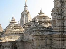
Mahabodhi Temple: The temple stands in the east to the Bodhi Tree. Its architectural effect is superb. Its basement is 48 square feet and it rises in the form of a slender Pyramid till it reaches its neck, which is cylindrical in shape. The total height of the temple is 170 ft. and on the top of the temple are Chatras which symbolize sovereignty of religion. Four towers on its corners rise gracefully giving the holy structure a poise balance. This sacred edifice is like a grand banner unfurled by time to proclaim to the world the pious efforts of the Buddha to solve the knots of human miseries, to ascend above worldly problems and to attain transcendental peace through wisdom, good conduct and disciplined life.

Inside the temple, in the main sanctum, there is a colossal image of the Buddha in sitting posture touching the earth by his right hand. In this posture the Buddha accomplished the supreme enlightenment. The statue is of black stone but it has been guilder by the devotees. The entire courtyard of the temple is studded with large number of votive stupas. These stupas are of all sizes built during the past 2500 years ago. Most of them are extremely elegant in structural beauty. The ancient railings, which surround the temple, are of the first century BC and are among the very interesting monuments of the century.

Animesh Lochan Chaitya: It is believed that the Buddha spent one week here looking towards the great Bodhi tree out of gratitude, without twinkling his eyes.

Bodhi Tree: The present Bodhi Tree is probably the fifth succession of the original tree under which the Buddha had attained enlightenment. Vajrasana, the seat of stability, is a stone platform on which the Buddha is supposed to have sat in meditation gazing east, under the Bodhi tree.

Chankramana: This marks the sacred spot of the Buddha's meditative perambulations during the third week after pious enlightenment. It is believed that wherever the Buddha put his feet lotus sprang up.

Ratnagarh: The Buddha spent one week here, where it is believed that five colors came out of his body.

Other Treasures of Bodhgaya: 80 ft Statue of the Buddha, Lotus Tank, Buddha Kund, Rajayatana, Brahm Yoni, Chinese Temple & Monastery, Burmese Temple, Buddhist Monastery of Bhutan, International Buddhist House & Japanese Temple, Thai Temple & Monastery, Tibetan Monastery, Archaeological Museum. Sujata village (2 kms), Dungeshwari Hill (Prag bodhi) (22 kms by road), Maitraya Project (3 kms).

PLACES AROUND BODHGAYA
Sun Temple (32 km): It is a famous temple of the Sun God at Deo and has a beautiful architecture similar to the Konark Temple in Orissa. This place is famous for the 'Chhat' festival which is held in the month of October-November.

Pretshila Hill (12 km, Gaya): This hill adds to the beauty of Gaya. It is about 10 kms from the Ramshila hill. Just below the hill is the Brahma Kund. After taking bath in this pond people go for the 'Pind Dan' which involves performance of religious rites and offering donations and charity for the peace of souls of one's parents and ancestors. On top of the hill the Queen of Indore, Ahilya Bai, built a temple in 1787popularly known as Ahilya Bai Temple. This temple has always been an attraction for the tourists due to its unique architecture and magnificent sculptures.

Vishnupad Temple (12km, at Gaya): In 1787 Queen Ahilya Bai built the Vishnu temple on the banks of river Falgu. The temple has some great architecture and design which attracts devotees and tourists alike. A 30-meter high octagonal tower overshadows this temple.

Barabar Caves (41 km): It is an important archaeological site. The caves carved out from solid rocks bear details of the life of the Buddha. The interior of these caves is chiseled to a wonderful polish. The carvings in the caves reflect the skill with which these caves were carved out. These caves were built in the 3rd century and are fine examples of the skill which the Indian mansion had attained at that time. These caves of Mauryan period are rightly considered to be the origin of Indian cave architecture. It was here in these caves where the Buddha had meditated for some time and concluded that the ultimate knowledge can not be attained through mortification of the flesh.

Rajgir (80 kms): Rajgir was the capital of the mighty Magadhas, described in Mahabharata, during the 6th century BC. It is one of the most important tourist places in India. Being located in a valley, Rajgir is a very scenic place. The attractions include the Ajatshatru fort, Shanti Stupa, Venu van, Karanda tank, Sonbhandar caves, Bhimbisar jail, Gridhkuta and hot water springs and the forestry. There is an aerial ropeway for adding charm to the tour.

Nalanda (96 kms from Bodhgaya): The place where an ancient university, famous all over the world existed, which is 62 km from Bodhgaya and 90 km south of Patna. In this first residential international university of the world, 2,000 teachers and 10,000 monks students from all over the Buddhist world lived and studied here. Nalanda is a place to understand the cultural richness of India during 5th century AD. The excavations have revealed some very interesting facts regarding the ancient university, and the artifacts obtained are naturally a must for every visitor.

Gaya (17 kms from Bodhgaya): Gaya is one of the most sacred Hindu destinations. The Vishnu temple is the central pilgrimage centre and people believe it has been constructed on the footprints of Lord Vishnu. Hindus believe that if a person's last rites are performed in Gaya, the soul attains Moksha, so thousands come here to offer the last rites and funerary offerings for their ancestors, every year. Main attraction is Vishnupad temple.

FAIRS & FESTIVALS
The meditation institutes of Bodhgaya organize a number of conventions, special meetings and discourses. These are usually held in the months of January and February. Travelers seeking peace of mind and spiritual upliftment must visit these programs. Important Buddhist religious festivals are celebrated with great fervor in Bodhgaya.

HOW TO REACH
By Air: The nearest airport is at Gaya 7 Kms and Patna 135 kms. Indian Airlines and Sahara Airlines connect Patna to Calcutta, Bombay, Delhi, Ranchi, Lucknow and various other cities.

By Rail: The nearest railway station is Gaya (17km).

By Road: Bodhgaya is well connected by road to Gaya (17km), Nalanda (101 km), Rajgir (78 km), Patna (135km), Varanasi (252 km), Calcutta (495km)

Friday, November 26, 2010

Kovalam

Literally meaning “a grove of coconut trees”, Kovalam is barely 10 km from Thiruvananthapuram, the capital of Kerala. Three small beaches comprise the town of Kovalam. Among them, the southernmost beach, Lighthouse Beach, is the most visited one. Once, this beach was an angler’s ecstasy. It still is home to some small villages, just a few kilometers away, which belong to the fishing neighborhood. With time, it has been converted into a happening tourist spot. The typical Kerala massage-providing sessions of rejuvenation are available at the parlors sited a few kilometers away along the beaches.

One of the chief tourist destinations in Kerala, the town of Kovalam experiences heavy influx of tourists all through the year from various parts of India and the world. Kovalam Beach actually is broadly composed of three adjacent crescent beaches, Lighthouse, Samudra, and Hawah each separated by rocky promontories. Best visited during the months from September to March, the Kovalam Beach is one of the choicest holidaying options comprising aquamarine waters, gleaming sands, and palm fringes.

Kovalam Beach
The Kovalam beach is probably the finest among all tourist attractions in Kovalam with its coconut fringes, palm beer, seafood and the revitalizing Ayurvedic massages that are available at the adjacent parlors. Furthermore, the comforting sunbath and suntan facilities at the beach are some of the major tourist attractions. Swimming, yogic exercises, fresh seafood and diving in the Arabian Sea are among some of the other entertainment facilities at the beach.

Catamaran cruises
Some of the most popular activities here include the Catamaran cruises, on the country rafts. Very recently a new tour operating company of Trivandrum has found a new package suitable for deep-sea fishing. This new project revolves around the Vizhinjam fishing harbor, at hardly 4 km to the eastern side of Kovalam Beach. Water sports lovers can make good use of surfboards and boogie boards that are obtainable on rental basis on the beach.

Ayurvedic Massage
Among other alluring tourist activity options are the Ayurvedic massages and treatments provided at several resorts and hotels on your tour to Kovalam. In Kovalam There are a number of Yoga centers as well. Recitals of some of the cultural Kerala art forms like Kathakali and ethnic martial art, Kalarippayattu can be extremely fulfilling.

Private Beaches
Kovalam Ashok Beach Resort, Somatheeram, Coconut Bay Beach Resort, Niki’s Nest, Uday Samudra Beach Resort, Surya Samudra Beach Garden, and Hotel Samudra are some of the most frequented among innumerable beach holiday resorts. Most of these private beaches are positioned in close proximity to Vizhinjam at hardly 8 km away from Kovalam.

Excursions around Kovalam
At just sixteen kilometers north of Kovalam, the holy city of Anantha, Thiruvananthapuram City can make for an exhilarating trip from Kovalam. Sri Padmnabhaswamy Temple is a significant tourist site of this city. Puthan Malika or Horse Palace is a wooden palace, situated near the Temple. The assets of the royal family and the very structure of the palace are some of the appreciative elements of the place. Located few meters away, the Chalai Market is a sprawling typical Keralite marketplace. The Napier Museum constructed in Indo-Saracenic Style, is positioned just 3 km away.

Positioned about 60 km away from Thiruvananthapuram city, the hill resort, Ponmudi is known for its tea plantations and jungle streams. Another lovely site to be visited is Kanyakumari (Cape Comorin), the southern tip of the Indian subcontinent. Sited 90 km to the east of Kovalam where three oceans converge, Kanyakumari is located in the state of Tamil Nadu. A few moments on the Vivekananda Rock here located exactly on the sea can be an extremely soothing experience. Padmnabhapuram Palace, the second largest wooden palace in Asia, on your way to Kanyakumari, is a major tourist attraction in Kovalam.

Best Season, Climate, and Clothing
Kovalam is best visited during the months between September and March. In winter the average temperature ranges between 30 and 32 degree Celsius while the summer temperature hovers around 30 to 35 degree Celsius. Rains start around the first week of June and continue till early August. The second turn of monsoons starts towards late October and lasts for the next two weeks.

How to Reach Kovalam
Kovalam is comfortably reachable by air and rail alike. The Thiruvananthapuram International Airport is hardly 14 km away from the Kovalam town. Kovalam is linked with the major Indian cities like New Delhi, Mumbai, Chennai and Bangalore by Indian Airlines and Jet airways. Regular rail services are accessible to and from Thiruvananthapuram Central Railway Station which happens to be the nearest railway station to Kovalam connecting to all major parts of India.

Wednesday, November 24, 2010

Srinagar - Paradise on Earth

Srinagar is the summer capital of the state of Jammu and Kashmir and is the pride of the beautiful valley of Kashmir. Srinagar is famous for its lakes and the charming rows of houseboats floating on them. It is also known for traditional Kashmiri handicrafts and dry fruits.

LOCATION
Srinagar is located in the western part of the state of Jammu and Kashmir, in the northern region of India. It is located in the Kashmir valley. River Jhelum passes through Srinagar city. Srinagar is 876 km north of Delhi. The weather in Srinagar is alpine. Summers (April-June) are mild and winters are cold (November-February). It experiences heavy snowfall in December-February.

BEST TIME TO VISIT
The best time to visit Srinagar is during summers between April and June.

HISTORY
The history of the Kashmir valley has been turbulent. In the 3rd century BC, it was a part of the great Mauryan Empire. Later on, this region flourished under the rule of the Kushans in the 1st century AD. It was an important Buddhist center around this time. In the 6th century, it was a part of the kingdom of Vikramaditya, the ruler of Ujjain.

Local Hindu rulers ruled it until the 14th century, after which Muslims invaded and ruled it. Srinagar was a part of the Mughal Empire in the medieval period. However, with the decline of the Mughal Empire and the rule of the Pathans, the fortunes of the area gradually dwindled. In 1814, it became a part of the Sikh empire, when Ranjit Singh defeated the Pathans. However, the British defeated Ranjit Singh and according to the treaty of Lahore in 1846, they installed Gulab Singh as the independent ruler of Kashmir.

The descendents of Gulab Singh ruled Kashmir under the vigilance of the British till 1947. Hari Singh, the great grandson of Gulab Singh, merged this princely state into India in 1948, when Pathan marauders from Pakistan tried to overrun this state.

TOURISTS ATTRACTIONS
The valley of Kashmir, in which Srinagar is located, is also referred to as being a heaven on earth. The Mughal emperor Jahangir was so captivated by the beauty of this valley that he exclaimed "Gar firdaus, ruhe zamin ast, hamin asto, hamin asto, hamin asto" (If there is a heaven on earth, it's here, it's here, it's here). There are a number of tourist places in and around Srinagar.

The Dal Lake is an important tourist attraction of Srinagar. It is located on the eastern end of the city. The Dal Lake comprises of a series of lakes, including the Nagin Lake some 8 km from the city center. One can enjoy the panoramic view of the mountains surrounding Srinagar from this lake. Travelers can enjoy taking a ride on traditional Kashmiri boats or the Shikaras to explore the intricate maze of waterways of this lake.

The other major attractions of Srinagar city are the well laid out Mughal styled gardens. The Shalimar Bagh and the Nishat Bagh are beautiful gardens located to the far eastern side of the Dal Lake. One can take a stroll amongst these green and attractive gardens and enjoy the waterworks within them.

The temple of Shankaracharya is another important place to visit in Srinagar. Jaluka, the son of emperor Ashoka, built it in the 3rd century BC.

PLACES AROUND SRINAGAR
There are number of interesting places to visit near Srinagar. Most of these places are located amongst picturesque settings of the mighty Himalayas. Apart from natural beauty, they offer a number of adventure activities to the traveler.

Gulmarg is 52 km southeast of Srinagar and is located at an altitude of 2730 m above sea level. In summers, the meadows of Gulmarg are laden with flowers. In winters, the snow-covered slopes of Gulmarg turn into a skiing resort, which attracts the traveler seeking adventure and thrill. It is a popular trekking destination and boasts of the world's highest golf course.

Sonamarg is 80 km northeast of Srinagar and is located at an altitude of 2740 m. It is set in a valley amongst glaciers and placid lakes. The flower laden meadows, panoramic view of the lofty snow covered Himalayan peaks, and a number of trekking and hiking trails have made Sonamarg a popular tourist destination.

Pahalgam is 95 km east of Srinagar and is located in the quiet Liddar valley, at a height of 2130 m. It provides an ideal setting for activities like hiking, trekking and fishing. It is also the starting point of the annual pilgrimage to the holy cave of Amarnath.


SHOPPING IN SRINAGAR
Srinagar is famous for its traditional Kashmiri handicrafts. The Handicraft items make excellent souvenirs from Srinagar. Besides the number of utilitarian items of daily use, Woolen and silk carpets from Srinagar are specialties. The carpets are not only known for their highly intricate decorations and patterns, which show a strong Islamic/Persian influence, they are also renowned for their durability and subtle colors. Chain-stitch carpets from Srinagar are also popular craft items.

Exquisite papier-mâché items such as boxes, vases, replicas of samovar (metal container used for heating water for tea), houseboat models, etc., in all shapes and having bright colors and designs also attract the tourists.

The handicrafts repertoire of Kashmir is incomplete without woolen shawls and woodcarving. You may purchase richly embroidered woolen shawls in all colors and intricate designs in Srinagar. Apart from regular woolen shawls, you can also buy Pashmina shawls (made from the hair of ibex), which is a highly valued shawl made in Kashmir. As Kashmir is the only state in India where walnut trees grow, craftsmen here create intricate carvings on walnut wood to make items like tables, chairs, stools, fruit bowls, partitions, etc., that have rich floral and trellis patterns carved on them. All these handicraft items make options for gift items from Srinagar.

HOW TO REACH
BY AIR - Srinagar is well connected by air with Delhi.

BY RAIL - Srinagar does not have a railway station and the nearest railhead is Jammu Tawi, which is 305 km from Srinagar.

BY ROAD - It is well connected by road to important places like Chandigarh (630 km), Delhi (876 km), Jammu (298 km), Leh, Kargil, Gulmarg, Sonamarg, and Pahalgam.

Tuesday, November 23, 2010

Nagpur - City of Oranges

Nagpur, known as the city of oranges, is the third largest city in the western Indian state of Maharashtra after Mumbai and Pune. Nagpur is one of the major industrial cities of Maharashtra. Nagpur is important geographically as it lies practically at the centre of India with the country's geographical centre being situated here. Nagpur is well-known throughout India as a trade centre for high-quality oranges grown in the surrounding region and hence the city is also known as Santra Nagari.

HISTORY OF NAGPUR
Gond prince of Deogad kingdom, Bhakt Buland, founded Nagpur in the early 18th century in the Chhindwara district. He tried to change the life of Nagpur as his new capital after seeing the advantage of civilized life of Delhi. His successor Chand Sultan too continued the work of Bhakt Buland. Disputes regarding succession arose with the death of Chand Sultan in 1739.

Maratha governor of Berar, Raghuji Bhonsle, tried to restore his elder son to the throne, and the control of Nagpur slowly passed on from the Gonds to the Marathas. Later Nagpur became the capital of the Bhonsles. Bhonsles lost to the British and Nagpur came under British influence in 1817. Raghuji III died without leaving any heir in 1853. As a result, the city came under the full control of British under Lord Dalhousie's Doctrine of Lapse.

Nagpur became the capital of the Central Provinces of India in 1861. With the advent of the Great Indian Peninsula Railway (GIP) in 1867, its development spurred as a trade centre.

After Indian independence, Nagpur became the capital of Madhya Bharat state (C.P. and Berar). In 1960, the Marathi majority Vidarbha region was merged with the new state of Maharashtra and Nagpur was designated the second capital of Maharashtra state, alternating with Bombay as the seat of the Maharashtra state legislature.

TOURIST ATTRACTIONS OF NAGPUR
Gavilgad Fort: It is located near the hill station of Chikhaldara in Amravati district. The Hindu rulers originally constructed Gavilgad fort. It is located at a height of about 370 ft above sea level (MSL). Historians believe that it is 200-300 years old, although the fort's history is not known till date.

Magnificent Forts of Balapur: The forts of Balapur are named after goddess Baladevi. Balapur has turned into a seat of pilgrimage and a tourist spot over the years. It is located between the two rivers of Mana and Mhais. This place is at a distance of 6 km from the railway station.

Lonar Lake: Lonar Lake is the third largest natural salt-water lake in the world. The lake has also a dam of 1800 m. It comes after Bosmatvi Lake in Ghana, which has a diameter of 10000 m and New Cubec in Canada with a Dai of 3500 m.

Vidarbha Pandhari Kundinpur: It is located on the banks of Wardha River in Tiwsa Tehsil of Nagpur. It is about 120 km from Nagpur. There organize an annual ten-day fair during Karthik Purnima that attracts not less than 50000 devotees.

Markandeya Temple: It is located in Chamorshi Tehsil in Gadchiroli district. The shortest route is via Milswali-Sakhri, which is about 183km. Markandi can be also reached by taking Nagpur - Chandrapur - Mul Road.

Naranala Fort: Narnala Fort is located in Akola district in Maharashtra. The fort is still in a good condition. The fort is located amidst forest. The fort is well maintained and is worth giving a shot. Neglect of the Archaeological Survey Department is visible in this fort. The fort has a fortress wall and beautiful bastions. Akola is well connected by road with the important and big cities of Maharashtra. Hotels are available in Akola.

PLACES TO SEE NEAR NAGPUR
Adasa: Adasa is located at a distance of 45 km from Nagpur. This small village has a plethora of ancient and magnificent temples. There is also a Ganapati Temple here, which is worth to be visited. The idol of the Lord is a single stone, set up to facilitate easy worship for the devotees. This place is easily accessible from Nagpur with many buses are plying from Nagpur, Kamleshwar and Saoner.

Kanha: It is located at 275 kms from city. It is situated in the pristine forest of Central Indian State of Madhya Pradesh. It is on e of the best place in India, to observe the tiger's activity.

Khekranala: Khekranala is situated at a distance of 55 km from Nagpur. There is a beautiful dam at this place. The location of the site is so greenery and peaceful, as it is in the range forest of Khapra. Dense foliage covers the water reservoir.

Markanda: Markanda is a cluster of nearly 24 temples, which resembles the architecture of the Khajuraho temples. This small town is located on the left bank of Vainganga River, which is famous as a religious site. The place derives its name from Sage Markandeya.

Dhapewada: Dhapewada Lake is 8 km from Ramtek and 60 km from Nagpur. This place has a small temple of Vithoba lies peacefully on the banks of the Chandrabhaga River. It has a variety of water sports to offer as well. This place is known to be the Pandharpur of Vidarbha. Khindsey Lake is another beautiful water body set amidst the green stretch of the Ramtek hill. This place is an ideal picnic spot.

Nagardhan: Nagardhan too has a fort, which is believed to be constructed by the Bhonsles. Gifted with an abundance of wild life, Nagzira has a wildlife sanctuary resting in natural domains that are a harmonious combination of lush greens and water bodies. Gaur, sambar and deer can be seen here.

Nawegaon Dam: Nawegaon Dam is the most popular forest resort of Vidarbha. The resort provides different adventure sports. Kolu Patel Kohli built this dam at the start of the 18th century. A placed lake adorns the hub of the hill ranges. There are also watchtowers to catch the wildlife in action. There is a deer park near the dam as well called Dr. Salim Ali Bird Sanctuary, along with three fascinating gardens and children's park.

Ramtek: Ram temple, which is more than 600 years old and Jain Temple, which has some beautiful carvings and sculpture are the main attractions of Ramtek. Ramtek is at a distance of 50 km from Nagpur. Lord Rama, Sita and Laxman were believed to be visited this place. Kalidas composed Meghdoot in this place.

Pavnar: Strategically located on the verge of the Dham River, Pavnar is of extreme historical importance. Its name derived from a Rajput ruler Pawan. It forms one of the most prehistoric colonies in the district. Gandhi Kuti and Paramdham Ashram of Vinobaji are the attractions of this place.

NAGPUR SHOPPING
Nagpur being a major city of Maharashtra has quite wide ranges of shopping places. Street shops are there at major streets for fashionable items as well as the show rooms for the deeper pockets. Sitabuldi, WHC Road, Dharampeth Road, Residency Road (Sadar) are famous for Shopping. Poonam Chambers in Chhindwara Road is a shopping mall for branded clothes and non-branded clothes, shoes, super bazaar, gifts and cards, jewellry shops, furniture, snacks and fast food, and music.

Nagpur is famous for its world-class oranges. It is claimed to be one of the most remunerative potential foreign exchange earning crops of not only of this region but also as one of the horticultural crops after mango and banana at national level in India. Orange products like jam, jelly, marmalade and fruit squash can also be purchased in cheapest rates with best quality. Oranges are cultivated in 80000 hectares in the entire Vidarbha region with a total production of nearly 5 lakh tons. Nagpur orange in Nagpur district is cultivated in 20, 965 hectares area.

Nagpur is flourishing on trades like cotton/handloom textiles, wood, tobacco, machine tools and plastics. Moreover Nagpur is the home for largest automakers Mahindra & Mahindra Ltd., Ashok Leyland Ltd., reputed steel makers Nagpur Engg. Co. Ltd (NECO), Sunflag Iron Steel Co. Ltd., Nippon Denro Ispat Ltd., largest paper maker Ballarpur Paper Mills, finest textile maker Raymond Ltd. (India), largest cement makers Associated Cement Companies Ltd., Ambuja Cements ltd., L & T Cement (Larsen & Tubro Ltd.), Birla Cement works (Manikgarh Cement Ltd.),

FAIR AND FESTIVALS OF NAGPUR
Marbat: Marbat is celebrated only in the Nagpur region, especially in the Nagpur city. People prepare statues of evil forces and take out procession in this festival. These statues are burnt at the end, and assumed that all evil forces are burnt. It is believed that the city would be free from all types of evils after it.

Ramjanam: This festival is organized on the birthday of Ramchandra. Ramjanam is celebrated with great enthusiasm and brotherhood in Nagpur. A rath yatra is taken out from the Ram Mandir to major parts of the city. Rath yatra is the procession of God Shri Ramchandraji on chariot. The rath yatra wraps up at the same location where it started.

To welcome Ram Chandraji, nearly 2,00,000 people gathers on both sides of the streets. Procession starts with the youngsters on skating wearing traditional dresses. Tribal dances are also performed in front of the chariot. Wearing masks of different Gods, like Ganesh and Hanuman, young boys and girls march ahead of chariot.

HOW TO REACH NAGPUR
By Air: Nagpur is connected with domestic flights with the cities of Mumbai, Calcutta, Delhi Hyderabad, Pune, Bhubaneswar and Raipur. Nagpur's Sonegaon airport is nearly 8 km south of the city.

By Rail: Electrified broad gauge railway track connects Nagpur to all four major cities and villages of India with Nagpur. Nagpur railway station is an important rail junction on the Central and Southeastern lines.

By Road: Bombay Calcutta NH-6 and Kanyakumari Varanasi NH-7 pass through the city. This city is well connected by road with major cities and villages in and out the state of Maharashtra.

Monday, November 22, 2010

Pune - Queen of the Deccan

Pune is Maharashtra's second city, which lies close to the Western Ghat Mountains, on the edge of the Deccan plains as they stretch away to the east. Pune is the cultural capital of the Maratha people, which is also known as the "Queen of the Deccan". Pune is a contrast of history and modernism. Pune is considered as the Oxford of India - with its many educational and research institutions apart from other institutions for sports, yoga, ayurveda, culture and social services. Pune is nowadays also seen as a potential city for massive growth of Information Technology. Pune is a city with a future that promises to be as interesting as its history.

Long-standing bastion of the Maratha Empire and home to the legendary Raja Shivaji, the Pune district is marked by magnificent land and sea forts, testimony to its glorious past.

After Shivaji, the early 18th century saw the emergence of the Peshwas, a Maratha family that grew from being ministers at the court into a major political power over the next few decades. However, after the battle of Panipat in 1761, the Maratha Empire began to decline and in 1818, Pune was taken over by the British East India Company.

Today, Pune is the centre of traditional Marathi culture, in which education, arts and crafts, and theatre are given pride of place. It has one of India's oldest universities and its numerous colleges attract both Indian and international students, which is probably why it is called the Oxford of the East.

Pune is slowly becoming a cosmopolitan city and is now an important commercial centre. The narrow winding roads of the old Pune offer an interesting contrast to the open, spacious new city. However, Pune retains the old-world charm and its many quaint characteristics, including the omnipresent cyclists, rickshaws and a daily siesta hour that is taken very seriously indeed.

Surrounded by verdant hills and beautiful lakes, Pune has a temperate climate and is among the greenest urban areas in the country.

HISTORY
The city was one of the pivotal bases of the 17th century Maratha ruler Chhatrapati Shivaji, who was born at the Shivneri Fort here. Pune became the seat of the enterprising Peshwas, under whom Maratha power rose into a major political force. The Peshwas were renowned patrons of the arts and in their time, enriched the city with temples, gardens and educational institutions. After the Battle of Koregaon in 1818, Pune fell into the hands of the East India Company. It was here that Lokmanya Bal Gangadhar Tilak introduced the principle of Swadeshi during the Freedom Movement. The British proposed to transform the city into a 'monsoon capital' but instead developed it into a 19th century Indian army town and renamed it Poona.

TOURISTS ATTRACTIONS
The most important landmark of Pune is the residence of the self-proclaimed guru, Bhagwan Rajneesh, also known as Osho. The ashram in Pune still attracts thousands of devotees, sightseers, curious onlookers and lots of controversy. The Shaniwarawada Palace with its pleasant gardens and huge outer walls is another must visit in Pune.

The Raja Kelkar Museum with unusual, the antique and the artistic collections draws several tourists. The major exhibits are the 17th century miniatures, of musical instruments, of antique pottery, and unusually, betel-nut cutters and brass padlocks. The other must visit museum is the Tribal Museum near the railway station.

The Gandhi National memorial, in the Aga Khan palace is also an important landmark of Pune. The 8th century rock-cut temple, the Ptaleshwar Temple on a hill a little outside town is one of the most popular temples, dedicated to goddess Parvati. There is a famous Muslim shrine, the Qamarali Darvesh that has a stone that is reputed to levitate. Twenty-five kilometers south-west of Pune, perched on a hill-top, is one of Maharashtra's many forests, Sinhagad, or the Lion Fort.

For enjoying the gorgeous greens Pune offers the Bund gardens on the banks of the river Mula-Mutha.

FAIR & FESTIVALS
The festivals which are celebrated in Pune are:-

The Ganesh Festival: Lord Ganesh, the patron deity of Maharashtra, is the God of wisdom. The 11-day festival begins with the installation of beautifully sculpted Ganesh idols in homes and mandaps, colorfully decorated, depicting religious themes or current events. People take Ganesh idols in procession to the accompaniment of music and dance for immersion in the sea or nearby river or lake on the 11th day.

Diwali Festival: The most beautiful of all Indian festivals, Diwali is a celebration of lights. The Diwali night in particular is a delightful feast to watch. On the same night "Laxmi Poojan" is held and the Goddess is venerated. Legend has it that Laxmi the Goddess of wealth visits all the houses hence all the houses are well-lighted and kept open. Diwali also ushers the" Hindu New Year".

Holi: Each year, after a successful winter harvest, people get ready to welcome the spring with Holi - the festival of colors. Brightly colored powders are applied on faces, and there is plenty of music, dance and sweets to fill the rest of the day. The exuberant display of colors symbolizes the advent of a colorful and prosperous spring season.

BEST SEASON
Pune could be visited through out the year. The climate is absolute for traveling. In summer cotton clothes and in winters light cottons are advised.

HOW TO REACH
Pune is the second major city of Maharashtra after Mumbai. Pune is well connected to other parts of India and the Metropolitan city of Mumbai through road, railway, and air.

Friday, November 19, 2010

Allahabad - Holy place of the confluence of River Ganges, Yamuna and Saraswati

Allahabad is synonymous to Sangam. 'Sangam' actually means confluence in Hindi. The city has been named so because it is situated on the confluence of Ganges, Yamuna and mythical river Saraswati. That is why Allahabad is counted among the holiest of cities in India. A holy fair called Kumbh marks the place. These are of three types. The one that takes place every year is called 'Minor Kumbh'. Whereas the ones celebrated every 6 years and 12 years are called Ardh-Kumbh and Maha Kumbh respectively.

The Maha Kumbh that takes place every 12 years is the largest religious or for that matter, largest congregation of humankind on the earth. In the 1988 edition of Maha Kumbh, 15 million people took dip in a single day. Guinness Book holds the figure as a world record. During the Mela, whole of the city turns in to a camp of a sort. Separate camps are pitched on the bank of confluence for different sects of hermits who are always at war. There are as many as 13 different camps dedicated to various sub-sects of Vaishnavite and Shaivite sects. There are dedicated days for these dips that are calculated by astrologers.

Nevertheless, Allahabad is much more than that. There are other attractions too. Some of them like Alfred Park and Minto Park have historical importance where as some others like Allahabad University and IIIT is the temple of learning. The city is also known for its numerous museums that includes among others, Anand Bhawan and Allahabad Museum.

INFORMATION ABOUT ALLAHABAD
Allahabad is situated about 137 kms west of Varanasi at an altitude of 98 meters above sea level. Allahabad was known as Prayag and renamed as Allahabad by Akbar in 1583. Allahabad is a quiet and peaceful city and the site of Allahabad University, one of the great Universities of India. This university was built on the site of an ancient Ashram where sage Bhardwaj taught 10,000 students. This city is very sacred to the Hindus and is situated at the junction of the Ganga and the Yamuna rivers and the mythical underground Saraswati River. Various devotees have a bath at the ‘Sagam’ which is situated at the confluence of the Ganga, Yamuna and Saraswati River. Every year, thousands of people gather here for the pilgrimage. But, during the Kumbh Fair, about millions of people gather here and have a sacred bath at the Sangam. Today, Allahabad is a rapidly growing commercial and administrative city. The best season to visit Allahabad is from October to March.

HISTORY OF ALLAHABAD
Hiuen Tsang, the Chinese traveler visited Prayag in 643 AD. The Muslims first conquered Prayag in 1194 and was renamed as Allahabad by Akbar in 1583. After conquering Prayag, Akbar built a fort which stands majestically at the confluence on the Yamuna side. Khusrau, Jahangir’s eldest son, was also buried in the city. The Marathas took the town in 1739 but held it only until 1750 when it was sacked by the Pathans. Later, it was the headquarters of the British Government of the North-west provinces and Oudh and here the transfer of government from the East India Company to the crown was announced by Lord Canning in 1885 with one of its founders, Allan Octavian Hulme. The great Indian patriot, Motilal Nehru, father of Pandit Jawahar Nehru also lived in this city. Various excavations were also done in the city. Draupadi Ghat has revealed signs of extensive habitation and considerable quantities of Northern Black Pottery Ware of the type found across northern India to Taxila and beyond. It has been dated from between 1100 and 800 B.C. Two other sites in the city have revealed similar types of findings. On the present site of the Bharadwaj ashram, the remains of the Kushan period have also been found.

FESTIVALS IN ALLAHABAD
The Magh Mela is celebrated every year for 15 days in the moth of January in Allahabad and bathing in the river during this fair is considered very auspicious. The Kumbh Mela is the most important fair which is celebrated in Allahabad and moves every 3 years from Allahabad, to Haridwar, Ujjain and Nasik, returning Allahabad every twelth year. This fair was described by the Eric Newby as the greatest assemblage of people gathered together in a confined space for a single purpose anywhere on earth. The story behind the Kumbh Mela is that the Hindu gods and demons vied for the pot or kumbha that held the nectar of immortality or amrit. During the flight for possession, which lasted 12 days, Vishnu was running with the pot and four drops of amrit fell to earth, making four sacred places like Allahabad, Ujjain, Nasik and Haridwar.

TOURIST ATTRACTIONS IN ALLAHABAD
There are various temples and some monuments belonging to the Muslim period in Allahabad like Akbar's Fort and Khusrau Bagh. There are also some buildings which belong to the British period like the Alfred Park, Muir College or Allahabad University, St. Joseph’s Roman Catholic Cathedral, the Holy Trinity Church, High Court and Minto Park. Sangam is another famous attraction in Allahabad.

Akbar's Fort: The Akbar's fort was built by Akbar in 1584 which stands majestically at the confluence on the Yamuna River. It was the largest of his forts and has three massive gateways and 7 meters high brick walls. This fort is most impressive when you view it from the river. Most of the fort is not accessible to tourists and has an Ashoka Pillar and the Zenana Palace. The Ashoka Pillar was re-erected in the Akbar’s Fort on the order of Akbar and belongs to 232 BC. It was found lying on the ground of the fort in 1837 and was set up at the present site. The Ashoka’s inscriptions are inscribed on its polished 10.6 meters high sandstone shaft. Some inscriptions were later added by Emperor Samudragupta (A.D. 326-375). This is the only historical record of the great monarch’s life. Later, Mughal Emperor Jahangir added his own inscription on the pillar. A small door in the east wall of the fort, near the river, leads to the undying banyan tree which is believed to have existed for thousands of years.

Khusrau Bagh: The Khusrau Bagh contains the tomb of Prince Khusro, who was murdered in 1615 by his own brother as he rebelled against his own father Jahangir. After staging an unsuccessful rebellion against his father Jahangir in 1607, Khusro spent the next year in chains. Two of his closest associates were less fortunate. They were sewn into the skins of a freshly slaughtered ox and ass, mounted the wrong way round on donkeys and paraded through the streets of Lahore. The hot sun dried the skins and one died from suffocation. Khusro was also forced to ride an elephant down a street lined with the heads of his supporters. When freed, Khusro undeterred encouraged a plot to assassinate his father but was discovered. Khusrau was blinded, though he did regain partial sight and spent the rest of his life as a captive. Later, he was murdered by his own brother in 1615. The garden is a typical Mughal garden enclosure, entered through an 18 m high archway and houses the large, handsome tomb of Khusro. The burial chamber is underground and the decoration is plasterwork painted with birds, flowers and Persian inscription. The tombs of his Rajput mother and sisters are located near by.

Sangam: Sangam is situated at the confluence of the Ganga, Yamuna and the mythical underground Saraswati River. The sangam is a narrow spit of land where the rivers gently mingle and is quite shallow and muddy. At any time of day or year you will find here people bathing. Every year, thousands of people gather here for the pilgrimage and to have the sacred bath in its waters. But, during the Kumbh Mela, about millions of people gather here to have the sacred bath at the Sangam.

Anand Bhawan: Anand Bhawan is the place where the Nehru family lived and is now converted into a national monument. This home was given to the state by Indira Gandhi in 1970. This house contains many items belonging to the Motilal Nehru, the father of Jawaharlal Nehru, Jawaharlal Nehru, Indira Gandhi, Sanjay Gandhi and Rajiv Gandhi.

EXCURSIONS
Kausambi: Kausambi is situated on NH2, about 45 kms from Allahabad. The enormous ruins of Kausambi are spread through several villages. Kosam-Inam and Kosam-khiraj are the villages that carry names that still suggest their links with the ruins of the city of Kausam. According to the epics, Kausam was founded by a descendant of the Pandavas who left Hastinapur when it was destroyed by the Udayana. It is also one of the earliest Historical cities of the region. According to Hiuen Tsang, the Buddha preached here and in commemoration of the event, there are two monasteries. Some excavations were also made here. Many coins and terracotta’s discovered here are now displayed in the Allahabad City museum and Kausambi Museum at the Allahabad University.

HOW TO GET HERE
By Air: Allahabad is directly connected by Indian Airlines flights with Delhi, Patna, Gorakhpur, Lucknow and Varanasi. Bamrauli airport is about 10 km from the city center.

By Rail: Allahabad is situated on the main broad gauge route from Delhi to Kolkata. It is also linked to other cities by broad and meter gauge lines like Agra, Delhi, Kolkata, Mumbai, Jhansi, Kanpur, Varanasi and Lucknow.

By Road: Allahabad is located on the NH27 to Mangawan and NH2 from Delhi to Kolkata. It is also located near NH7 which runs from Varanasi to Kanyakumari. It is also connected with all major cities like Lucknow, Allahabad, Varanasi, Patna, Nagpur, Agra, Jhansi, Bhopal and Delhi.

Tiruchirappalli or Trichy

Situated in Tiruchirappalli district, on the banks of the River Kaveri (also spelt as Cauvery) is Tiruchirappalli, a city known for its educational institutions, industries, and temples. It is shortly called as "Tiruchi" or "Trichy".

Trichy is the district headquarters of the district of Tiruchirappalli and has its name for tourist attraction. The city is a thriving commercial centre in Tamil Nadu and is famous for artificial diamonds, cigars, handloom cloth, glass bangles and wooden and clay toys.


THE LANDMARK OF THE CITY
The most famous landmark of Tiruchirappalli is the Rock Fort Temple, a spectacular monument perched on a massive rocky out crop which rises abruptly from the plain to tower over the old city.

HISTORY OF TRICHY (TIRUCHIRAPPALLI)
Tiruchi itself has a long history dating back to the centuries before the Christian era when it was a Chola citadel. During the first millennium AD, it changed hands between the Pallavas and Pandyas many times before being taken by the Cholas in the 10th century AD. When the Chola Empire finally declined, Tiruchi passed into the hands of the Vijayanagar kings of Hampi and remained with them until their defeat, in 1565 AD by the forces of the Deccan Sultans.

The city and its fort, as they stand today, were built by the Nayaks of Madurai. It was one of the main centers around which the wars of the Carnatic were fought in the 18th century during the British-French struggle for supremacy in India.

PRIME ATTRACTIONS OF TRICHY (TIRUCHIRAPPALLI)
Viralimalai Sanctuary: Viralimalai is a small town situated at a distance of 30-km from Tiruchirappalli and 40-km from Pudukkottai. It is famous for its Murugan temple and the Peacock sanctuary. The town is bestowed with a large number of wild peacocks, which roam around the Murugan temple.

Sittanavasal: Located at a distance of 58-km from Trichy is Sittanavasal, a site of an ancient Jain monastery with fine fresco paintings in a rock cave. Many of them are typical of the 9th century Pandyan period and include exquisitely detailed pictures of animals, fish, ducks, people gathering lotuses from a pond and two dancing figures. There are also inscriptions dating back to the 9th and 10th centuries. Fresco paintings from the 7th century can be seen on the ceiling of the Ardhamandapam.

There are many pre-historic burial sites around Sittanavasal and among the relics unearthed are burial urns, cists and Kurangupatarai.

Government Museum: Situated at Thirukokarnam, the museum is located near the Pudukkottai station, at a distance of 40 km from Trichy. The rare collections in the sections of Geology, Zoology, Paintings, Anthropology, Epigraphy, Historical Records, etc., are very interesting. The museum is open on all days except Mondays.

Kudumianmalai: Kudumianmalai temple is located at a distance of 25-km from Trichy. The presiding deity is Lord Sikhagireeswara. There are beautiful sculptures and a thousand pillar-halls within the temple.

PLACES OF WORSHIP IN & AROUND TRICHY (TIRUCHIRAPPALLI)
Rock Fort Temple: The Rock Fort temple complex in Tiruchirappalli is a collection of three temples - the Manikka Vinayakar temple at the foot of the hill, the Uchhi Pillayar Koyil at the top of the hill and the Taayumaanavar Koyil (Shivastalam) on the hill. This Shivastalam is a rock cut temple on a hill and is the most prominent landmark in Tiruchirappalli that can be reached by a flight of steps on the way to the famous Ucchi Pillayar temple.

Gangaikondan Cholapuram: GangaikondaCholapuram is located in Udayarpalayam Taluk (also spelt as Taluka) of Perambalur district, at a distance of 100-km from Trichy. Rajendra I, a Chola ruler established GangaikondaCholapuram as his capital city and built a magnificent temple dedicated to Lord Shiva. Apart from the huge Nandi, there are some beautiful sculptures including a dancing Ganesha, a lion-headed well and a stunning piece depicting Rajendra being crowned by Lord Shiva and Parvati.

Kodumbalur: Also known as "Moovarkoil", Kodumbalur is 36-km from Pudukkottai and 42-km from Tiruchirappalli. It was formerly the seat of Irukkuvelirs, who were related to the Cholas. Of the three shrines of Moovarkoil only two exist now. Boodhi Vikramakesari built these temples in the 10th century AD. The architecture of the temple is unique among south Indian temples. The sculptures of Kalarimurthi, Gajasamharamurthi Ardhanariswara, Gangadaramurthi, etc. are interesting masterpieces of art. Nearby is the Muchukundeswarar temple of the early Chola period.

Sri Ranganathaswami Temple at Srirangam: Located 7-km from Trichy is Srirangam, the abode of the Supreme Lord, Sri Ranganatha, the reclining form of Lord Vishnu. The temple of Ranganatha, the largest in India, is of particular reverence to all Hindus. Srirangam is also listed as one of the Nava Graha Sthalas, or temples representing the planets.

Tiruvanaikkaval or Jambukeswara Temple: Situated 2-km east of Srirangam, this beautiful Shiva temple steals the show from the larger Ranganathaswami temple due to its excellent architectural design. The temple is named after the elephant, which is believed to have worshipped Lord Shiva here. Installed under an ancient Jambu tree, the lingam is partially submerged by water and meant to represent God incarnate as Water.

Avadayar Koil: Avadayar Koil, previously known as "Thiruperunthurai", is an important Shivasthala located at a distance of 8 miles from the Arantangi railway station and about 94-km from Trichy. The sculptural work of the temple is exquisite. It is perhaps the best architectural marvel in South India.

Gunaseelam: Located at a distance of 22-km from Trichy is Gunaseelam, a place famous for its temple for Lord Vishnu, known as "Prasanna Venkateswara".

St. John's Church: Built in 1812, St. John's Church has louver doors which open to convert it into an airy pavilion. The surrounding cemetery is also interesting.

Elakurichi: At a distance of 65-km from Trichy is Elakurichi, a place famous for the ancient church built by the famous Catholic Missionary, Constantine Joseph Beschi, popularly known as "Veeramamunivar".

Avur: Located at a distance of 30-km from Trichy is Avur, which is famous for an old church constructed by Father John Venantius Bouchet.

FAIRS & FESTIVALS OF TRICHY (TIRUCHIRAPPALLI)
The Float Festival celebrated during the months of March-April at the Rock Fort Temple draws crowds in huge numbers. Mohini Alangaram, Vaikunta Ekadasi, Garuda Seva, Flower Festival and the Car Festival (December-January) are the other main festivals celebrated at Srirangam.

SHOPPING IN TRICHY (TIRUCHIRAPPALLI)
Trichy is famous for its cigars and cheroots. Amongst handicraft are brassware, handloom textiles, pith models of temples and Rock Fort, wood and clay toys, jewellery, ornamental carved brass and copper plates inlaid with silver (Tanjore plates), brassware, silks, carpets and musical instruments.

HOW TO GET THERE
By Air: Tiruchirappalli has an airport (5-km) from the city. Various airlines connect Tiruchi with Chennai, Sharjah, Kuwait and Colombo.

By Rail: Tiruchi is an important junction on the Southern Railway. It connects Chennai, Thanjavur, Madurai, Tirupati, Tuticorin and Rameshwaram on the meter gauge, and Bangalore, Coimbatore, Mysore, Kochi, Kannyakumarai and Mangalore on the broad gauge.

By Road: Tiruchi is well connected by road with important places of South India. City bus service, tourist taxis, auto rickshaws and cycle rickshaws are available for local transportation.